You are here: Home > Network List > TA - USArray Transportable Network (new EarthScope stations) Stations List
> Station H41A Junction City, WI, USA > Earthquake Result Viewer
H41A Junction City, WI, USA - Earthquake Result Viewer
| Earthquake location: |
Colombia |
| Earthquake latitude/longitude: |
1.9/-76.4 |
| Earthquake time(UTC): |
2012/09/30 (274) 16:31:35 GMT |
| Earthquake Depth: |
170 km |
| Earthquake Magnitude: |
7.0 MB, 7.3 MW, 7.2 MW |
| Earthquake Catalog/Contributor: |
WHDF/NEIC |
|
| Network: |
TA USArray Transportable Network (new EarthScope stations) |
| Station: |
H41A Junction City, WI, USA |
| Lat/Lon: |
44.62 N/89.65 W |
| Elevation: |
348 m |
|
| Distance: |
44.1 deg |
| Az: |
346.354 deg |
| Baz: |
160.722 deg |
| Ray Param: |
0.07149342 |
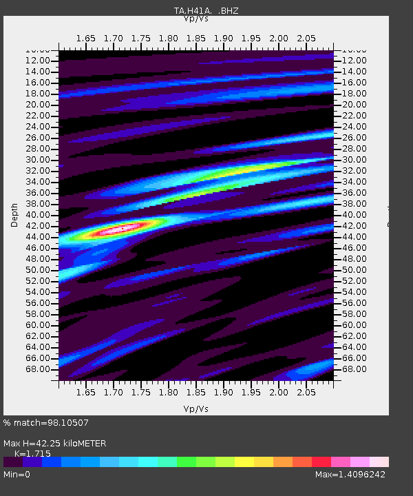
| Estimated Moho Depth: |
42.25 km |
| Estimated Crust Vp/Vs: |
1.72 |
| Assumed Crust Vp: |
6.41 km/s |
| Estimated Crust Vs: |
3.738 km/s |
| Estimated Crust Poisson's Ratio: |
0.24 |
|
| Radial Match: |
98.10507 % |
| Radial Bump: |
363 |
| Transverse Match: |
92.723724 % |
| Transverse Bump: |
400 |
| SOD ConfigId: |
478790 |
| Insert Time: |
2013-02-23 01:05:44.140 +0000 |
| GWidth: |
2.5 |
| Max Bumps: |
400 |
| Tol: |
0.001 |
|
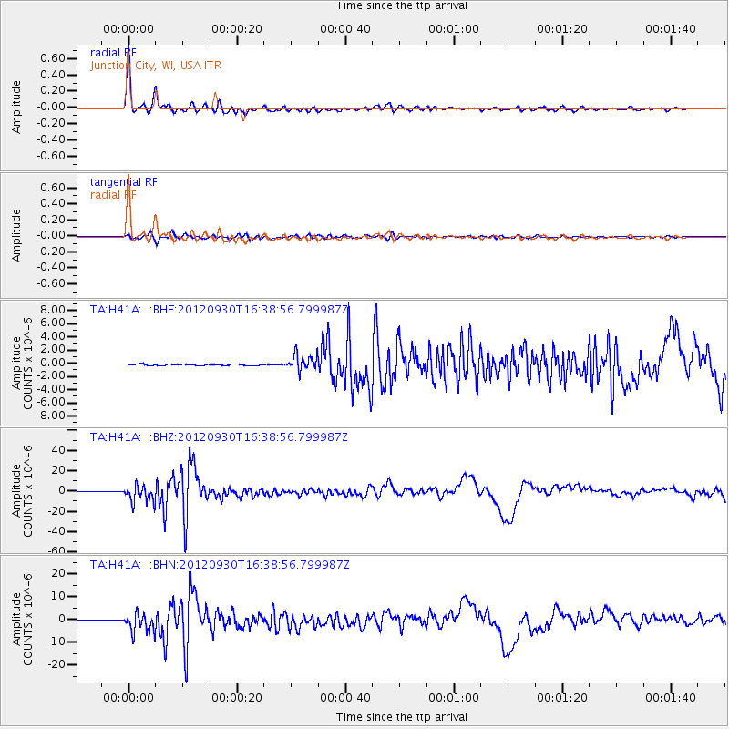
Signal To Noise
| Channel | StoN | STA | LTA |
| TA:H41A: :BHZ:20120930T16:38:56.799987Z | 70.44462 | 8.219652E-6 | 1.1668247E-7 |
| TA:H41A: :BHN:20120930T16:38:56.799987Z | 37.536022 | 4.1204835E-6 | 1.0977411E-7 |
| TA:H41A: :BHE:20120930T16:38:56.799987Z | 11.701517 | 1.1864072E-6 | 1.0138918E-7 |
| Arrivals |
| Ps | 5.0 SECOND |
| PpPs | 17 SECOND |
| PsPs/PpSs | 22 SECOND |


