You are here: Home > Network List > G - GEOSCOPE Stations List
> Station WUS Wushi, Xinjiang Uygur, China > Earthquake Result Viewer
WUS Wushi, Xinjiang Uygur, China - Earthquake Result Viewer
| Earthquake location: |
Egypt |
| Earthquake latitude/longitude: |
28.6/34.6 |
| Earthquake time(UTC): |
1993/08/03 (215) 12:43:04 GMT |
| Earthquake Depth: |
10 km |
| Earthquake Magnitude: |
6.0 MB, 5.7 MS, 6.1 UNKNOWN, 6.0 MW |
| Earthquake Catalog/Contributor: |
WHDF/NEIC |
|
| Network: |
G GEOSCOPE |
| Station: |
WUS Wushi, Xinjiang Uygur, China |
| Lat/Lon: |
41.20 N/79.22 E |
| Elevation: |
1457 m |
|
| Distance: |
38.3 deg |
| Az: |
58.81 deg |
| Baz: |
265.254 deg |
| Ray Param: |
0.07567026 |
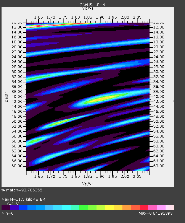
| Estimated Moho Depth: |
11.5 km |
| Estimated Crust Vp/Vs: |
1.61 |
| Assumed Crust Vp: |
6.353 km/s |
| Estimated Crust Vs: |
3.946 km/s |
| Estimated Crust Poisson's Ratio: |
0.19 |
|
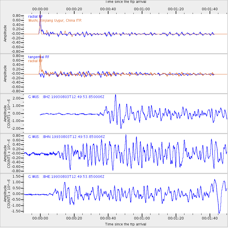
| Radial Match: |
93.785355 % |
| Radial Bump: |
400 |
| Transverse Match: |
76.467964 % |
| Transverse Bump: |
400 |
| SOD ConfigId: |
16938 |
| Insert Time: |
2010-02-27 00:52:27.831 +0000 |
| GWidth: |
2.5 |
| Max Bumps: |
400 |
| Tol: |
0.001 |
|
Signal To Noise
| Channel | StoN | STA | LTA |
| G:WUS: :BHN:19930803T12:49:53.850006Z | 0.8943791 | 3.5857656E-8 | 4.0092235E-8 |
| G:WUS: :BHE:19930803T12:49:53.850006Z | 1.1808311 | 3.866748E-8 | 3.2745987E-8 |
| G:WUS: :BHZ:19930803T12:49:53.850006Z | 1.1398884 | 5.6572702E-8 | 4.963003E-8 |
| Arrivals |
| Ps | 1.2 SECOND |
| PpPs | 4.4 SECOND |
| PsPs/PpSs | 5.6 SECOND |


