You are here: Home > Network List > TA - USArray Transportable Network (new EarthScope stations) Stations List
> Station G59A Clarenceville, QC, USA > Earthquake Result Viewer
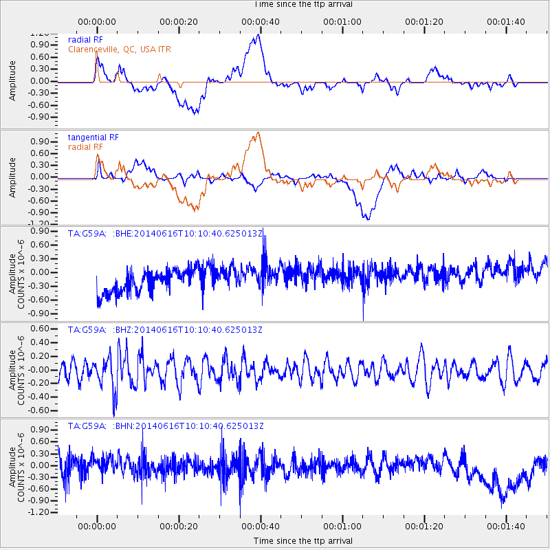
G59A Clarenceville, QC, USA - Earthquake Result Viewer
*The percent match for this event was below the threshold and hence no stack was calculated.
| Earthquake location: |
Mexico-Guatemala Border Region |
| Earthquake latitude/longitude: |
15.3/-91.9 |
| Earthquake time(UTC): |
2014/06/16 (167) 10:04:30 GMT |
| Earthquake Depth: |
10 km |
| Earthquake Magnitude: |
5.0 MW |
| Earthquake Catalog/Contributor: |
ISC/ISC |
|
| Network: |
TA USArray Transportable Network (new EarthScope stations) |
| Station: |
G59A Clarenceville, QC, USA |
| Lat/Lon: |
45.08 N/73.18 W |
| Elevation: |
36 m |
|
| Distance: |
33.7 deg |
| Az: |
24.281 deg |
| Baz: |
214.064 deg |
| Ray Param: |
$rayparam |
*The percent match for this event was below the threshold and hence was not used in the summary stack. |
|
| Radial Match: |
21.12146 % |
| Radial Bump: |
400 |
| Transverse Match: |
23.663427 % |
| Transverse Bump: |
400 |
| SOD ConfigId: |
3390531 |
| Insert Time: |
2019-04-12 07:23:40.539 +0000 |
| GWidth: |
2.5 |
| Max Bumps: |
400 |
| Tol: |
0.001 |
|
Signal To Noise
| Channel | StoN | STA | LTA |
| TA:G59A: :BHZ:20140616T10:10:40.625013Z | 1.6973678 | 2.4891045E-7 | 1.4664498E-7 |
| TA:G59A: :BHN:20140616T10:10:40.625013Z | 0.8500092 | 1.9544208E-7 | 2.2992937E-7 |
| TA:G59A: :BHE:20140616T10:10:40.625013Z | 1.0123899 | 2.42222E-7 | 2.3925762E-7 |
| Arrivals |
| Ps | |
| PpPs | |
| PsPs/PpSs | |


