You are here: Home > Network List > TA - USArray Transportable Network (new EarthScope stations) Stations List
> Station R45A Skylar, Fairfield, IL, USA > Earthquake Result Viewer
R45A Skylar, Fairfield, IL, USA - Earthquake Result Viewer
| Earthquake location: |
Colombia |
| Earthquake latitude/longitude: |
1.9/-76.4 |
| Earthquake time(UTC): |
2012/09/30 (274) 16:31:35 GMT |
| Earthquake Depth: |
170 km |
| Earthquake Magnitude: |
7.0 MB, 7.3 MW, 7.2 MW |
| Earthquake Catalog/Contributor: |
WHDF/NEIC |
|
| Network: |
TA USArray Transportable Network (new EarthScope stations) |
| Station: |
R45A Skylar, Fairfield, IL, USA |
| Lat/Lon: |
38.29 N/88.28 W |
| Elevation: |
143 m |
|
| Distance: |
37.8 deg |
| Az: |
344.625 deg |
| Baz: |
160.321 deg |
| Ray Param: |
0.075298354 |
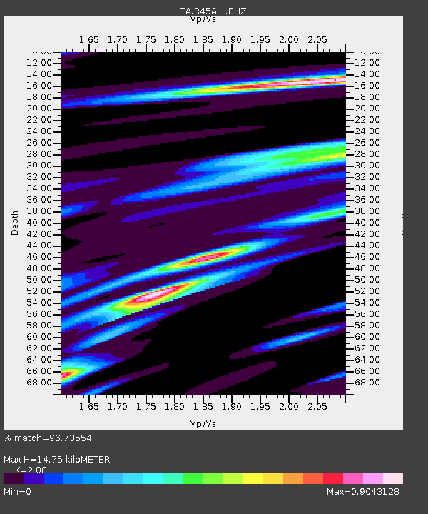
| Estimated Moho Depth: |
14.75 km |
| Estimated Crust Vp/Vs: |
2.08 |
| Assumed Crust Vp: |
6.444 km/s |
| Estimated Crust Vs: |
3.098 km/s |
| Estimated Crust Poisson's Ratio: |
0.35 |
|
| Radial Match: |
96.73554 % |
| Radial Bump: |
325 |
| Transverse Match: |
84.79551 % |
| Transverse Bump: |
400 |
| SOD ConfigId: |
478790 |
| Insert Time: |
2013-02-23 01:09:57.745 +0000 |
| GWidth: |
2.5 |
| Max Bumps: |
400 |
| Tol: |
0.001 |
|

Signal To Noise
| Channel | StoN | STA | LTA |
| TA:R45A: :BHZ:20120930T16:38:05.424987Z | 33.09982 | 5.2137757E-6 | 1.5751675E-7 |
| TA:R45A: :BHN:20120930T16:38:05.424987Z | 21.487555 | 2.1598512E-6 | 1.00516374E-7 |
| TA:R45A: :BHE:20120930T16:38:05.424987Z | 9.427848 | 1.0292483E-6 | 1.0917108E-7 |
| Arrivals |
| Ps | 2.6 SECOND |
| PpPs | 6.6 SECOND |
| PsPs/PpSs | 9.3 SECOND |


