You are here: Home > Network List > TA - USArray Transportable Network (new EarthScope stations) Stations List
> Station R46A Gibon Southern Titans, Haubstabt, IN, USA > Earthquake Result Viewer
R46A Gibon Southern Titans, Haubstabt, IN, USA - Earthquake Result Viewer
| Earthquake location: |
Colombia |
| Earthquake latitude/longitude: |
1.9/-76.4 |
| Earthquake time(UTC): |
2012/09/30 (274) 16:31:35 GMT |
| Earthquake Depth: |
170 km |
| Earthquake Magnitude: |
7.0 MB, 7.3 MW, 7.2 MW |
| Earthquake Catalog/Contributor: |
WHDF/NEIC |
|
| Network: |
TA USArray Transportable Network (new EarthScope stations) |
| Station: |
R46A Gibon Southern Titans, Haubstabt, IN, USA |
| Lat/Lon: |
38.21 N/87.51 W |
| Elevation: |
164 m |
|
| Distance: |
37.5 deg |
| Az: |
345.52 deg |
| Baz: |
161.503 deg |
| Ray Param: |
0.07545448 |
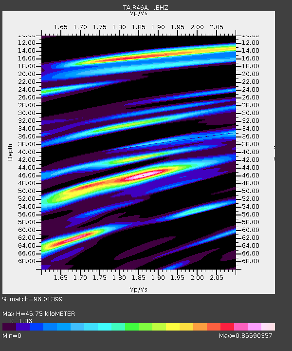
| Estimated Moho Depth: |
45.75 km |
| Estimated Crust Vp/Vs: |
1.86 |
| Assumed Crust Vp: |
6.444 km/s |
| Estimated Crust Vs: |
3.464 km/s |
| Estimated Crust Poisson's Ratio: |
0.30 |
|
| Radial Match: |
96.01399 % |
| Radial Bump: |
400 |
| Transverse Match: |
76.062546 % |
| Transverse Bump: |
400 |
| SOD ConfigId: |
478790 |
| Insert Time: |
2013-02-23 01:10:05.483 +0000 |
| GWidth: |
2.5 |
| Max Bumps: |
400 |
| Tol: |
0.001 |
|

Signal To Noise
| Channel | StoN | STA | LTA |
| TA:R46A: :BHZ:20120930T16:38:03.124999Z | 37.74712 | 4.9446603E-6 | 1.3099438E-7 |
| TA:R46A: :BHN:20120930T16:38:03.124999Z | 16.928143 | 2.3281868E-6 | 1.375335E-7 |
| TA:R46A: :BHE:20120930T16:38:03.124999Z | 10.622881 | 9.137153E-7 | 8.601389E-8 |
| Arrivals |
| Ps | 6.5 SECOND |
| PpPs | 19 SECOND |
| PsPs/PpSs | 25 SECOND |


