You are here: Home > Network List > TA - USArray Transportable Network (new EarthScope stations) Stations List
> Station T45A Paducah, KY, USA > Earthquake Result Viewer
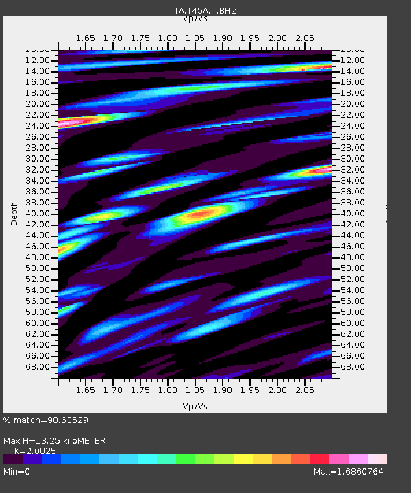
T45A Paducah, KY, USA - Earthquake Result Viewer
| Earthquake location: |
Colombia |
| Earthquake latitude/longitude: |
1.9/-76.4 |
| Earthquake time(UTC): |
2012/09/30 (274) 16:31:35 GMT |
| Earthquake Depth: |
170 km |
| Earthquake Magnitude: |
7.0 MB, 7.3 MW, 7.2 MW |
| Earthquake Catalog/Contributor: |
WHDF/NEIC |
|
| Network: |
TA USArray Transportable Network (new EarthScope stations) |
| Station: |
T45A Paducah, KY, USA |
| Lat/Lon: |
37.02 N/88.64 W |
| Elevation: |
119 m |
|
| Distance: |
36.7 deg |
| Az: |
343.451 deg |
| Baz: |
159.165 deg |
| Ray Param: |
0.0759219 |
| Estimated Moho Depth: |
13.25 km |
| Estimated Crust Vp/Vs: |
2.08 |
| Assumed Crust Vp: |
6.444 km/s |
| Estimated Crust Vs: |
3.094 km/s |
| Estimated Crust Poisson's Ratio: |
0.35 |
|
| Radial Match: |
90.63529 % |
| Radial Bump: |
400 |
| Transverse Match: |
71.63391 % |
| Transverse Bump: |
400 |
| SOD ConfigId: |
478790 |
| Insert Time: |
2013-02-23 01:10:17.184 +0000 |
| GWidth: |
2.5 |
| Max Bumps: |
400 |
| Tol: |
0.001 |
|

Signal To Noise
| Channel | StoN | STA | LTA |
| TA:T45A: :BHZ:20120930T16:37:56.249999Z | 25.952906 | 6.61611E-6 | 2.5492753E-7 |
| TA:T45A: :BHN:20120930T16:37:56.249999Z | 38.751297 | 9.338675E-6 | 2.4098998E-7 |
| TA:T45A: :BHE:20120930T16:37:56.249999Z | 17.656258 | 4.456919E-6 | 2.5242718E-7 |
| Arrivals |
| Ps | 2.4 SECOND |
| PpPs | 6.0 SECOND |
| PsPs/PpSs | 8.3 SECOND |


