You are here: Home > Network List > TA - USArray Transportable Network (new EarthScope stations) Stations List
> Station T46A Princeton, KY, USA > Earthquake Result Viewer
T46A Princeton, KY, USA - Earthquake Result Viewer
| Earthquake location: |
Colombia |
| Earthquake latitude/longitude: |
1.9/-76.4 |
| Earthquake time(UTC): |
2012/09/30 (274) 16:31:35 GMT |
| Earthquake Depth: |
170 km |
| Earthquake Magnitude: |
7.0 MB, 7.3 MW, 7.2 MW |
| Earthquake Catalog/Contributor: |
WHDF/NEIC |
|
| Network: |
TA USArray Transportable Network (new EarthScope stations) |
| Station: |
T46A Princeton, KY, USA |
| Lat/Lon: |
37.04 N/87.89 W |
| Elevation: |
169 m |
|
| Distance: |
36.5 deg |
| Az: |
344.409 deg |
| Baz: |
160.384 deg |
| Ray Param: |
0.07602912 |
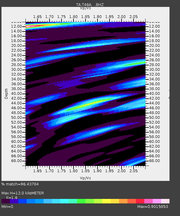
| Estimated Moho Depth: |
12.0 km |
| Estimated Crust Vp/Vs: |
1.60 |
| Assumed Crust Vp: |
6.444 km/s |
| Estimated Crust Vs: |
4.027 km/s |
| Estimated Crust Poisson's Ratio: |
0.18 |
|
| Radial Match: |
96.43784 % |
| Radial Bump: |
400 |
| Transverse Match: |
84.62895 % |
| Transverse Bump: |
400 |
| SOD ConfigId: |
478790 |
| Insert Time: |
2013-02-23 01:10:21.130 +0000 |
| GWidth: |
2.5 |
| Max Bumps: |
400 |
| Tol: |
0.001 |
|
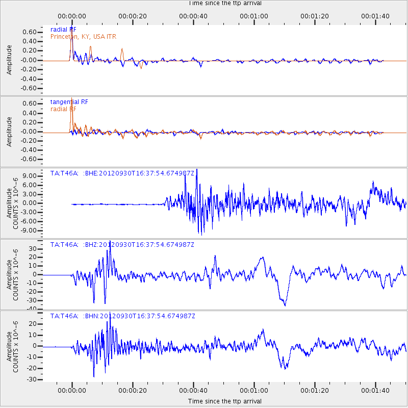
Signal To Noise
| Channel | StoN | STA | LTA |
| TA:T46A: :BHZ:20120930T16:37:54.674987Z | 32.457558 | 4.007832E-6 | 1.2347917E-7 |
| TA:T46A: :BHN:20120930T16:37:54.674987Z | 23.891857 | 2.7169956E-6 | 1.1372057E-7 |
| TA:T46A: :BHE:20120930T16:37:54.674987Z | 15.365873 | 1.0178323E-6 | 6.62398E-8 |
| Arrivals |
| Ps | 1.2 SECOND |
| PpPs | 4.5 SECOND |
| PsPs/PpSs | 5.7 SECOND |


