You are here: Home > Network List > TA - USArray Transportable Network (new EarthScope stations) Stations List
> Station X49A Woodville, AR, USA > Earthquake Result Viewer
X49A Woodville, AR, USA - Earthquake Result Viewer

| Earthquake location: |
Colombia |
| Earthquake latitude/longitude: |
1.9/-76.4 |
| Earthquake time(UTC): |
2012/09/30 (274) 16:31:35 GMT |
| Earthquake Depth: |
170 km |
| Earthquake Magnitude: |
7.0 MB, 7.3 MW, 7.2 MW |
| Earthquake Catalog/Contributor: |
WHDF/NEIC |
|
| Network: |
TA USArray Transportable Network (new EarthScope stations) |
| Station: |
X49A Woodville, AR, USA |
| Lat/Lon: |
34.51 N/86.33 W |
| Elevation: |
182 m |
|
| Distance: |
33.7 deg |
| Az: |
345.087 deg |
| Baz: |
161.852 deg |
| Ray Param: |
0.07752003 |
| Estimated Moho Depth: |
10.0 km |
| Estimated Crust Vp/Vs: |
1.70 |
| Assumed Crust Vp: |
6.476 km/s |
| Estimated Crust Vs: |
3.821 km/s |
| Estimated Crust Poisson's Ratio: |
0.23 |
|
| Radial Match: |
95.85692 % |
| Radial Bump: |
376 |
| Transverse Match: |
83.36917 % |
| Transverse Bump: |
400 |
| SOD ConfigId: |
478790 |
| Insert Time: |
2013-02-23 01:11:22.021 +0000 |
| GWidth: |
2.5 |
| Max Bumps: |
400 |
| Tol: |
0.001 |
|
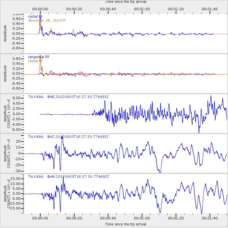
Signal To Noise
| Channel | StoN | STA | LTA |
| TA:X49A: :BHZ:20120930T16:37:30.774993Z | 26.5293 | 3.2919759E-6 | 1.240883E-7 |
| TA:X49A: :BHN:20120930T16:37:30.774993Z | 13.333757 | 1.528925E-6 | 1.1466573E-7 |
| TA:X49A: :BHE:20120930T16:37:30.774993Z | 6.658092 | 5.209817E-7 | 7.82479E-8 |
| Arrivals |
| Ps | 1.2 SECOND |
| PpPs | 3.8 SECOND |
| PsPs/PpSs | 5.0 SECOND |


