You are here: Home > Network List > TA - USArray Transportable Network (new EarthScope stations) Stations List
> Station V47A Nunnelly, TN, USA > Earthquake Result Viewer
V47A Nunnelly, TN, USA - Earthquake Result Viewer
| Earthquake location: |
Colombia |
| Earthquake latitude/longitude: |
1.9/-76.4 |
| Earthquake time(UTC): |
2012/09/30 (274) 16:31:35 GMT |
| Earthquake Depth: |
170 km |
| Earthquake Magnitude: |
7.0 MB, 7.3 MW, 7.2 MW |
| Earthquake Catalog/Contributor: |
WHDF/NEIC |
|
| Network: |
TA USArray Transportable Network (new EarthScope stations) |
| Station: |
V47A Nunnelly, TN, USA |
| Lat/Lon: |
35.83 N/87.52 W |
| Elevation: |
240 m |
|
| Distance: |
35.3 deg |
| Az: |
344.201 deg |
| Baz: |
160.436 deg |
| Ray Param: |
0.076698534 |
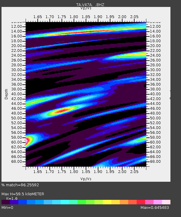
| Estimated Moho Depth: |
59.5 km |
| Estimated Crust Vp/Vs: |
1.60 |
| Assumed Crust Vp: |
6.476 km/s |
| Estimated Crust Vs: |
4.047 km/s |
| Estimated Crust Poisson's Ratio: |
0.18 |
|
| Radial Match: |
96.25592 % |
| Radial Bump: |
269 |
| Transverse Match: |
79.900795 % |
| Transverse Bump: |
400 |
| SOD ConfigId: |
478790 |
| Insert Time: |
2013-02-23 01:12:05.848 +0000 |
| GWidth: |
2.5 |
| Max Bumps: |
400 |
| Tol: |
0.001 |
|

Signal To Noise
| Channel | StoN | STA | LTA |
| TA:V47A: :BHZ:20120930T16:37:44.124999Z | 26.462564 | 3.613705E-6 | 1.3655915E-7 |
| TA:V47A: :BHN:20120930T16:37:44.124999Z | 22.004677 | 2.1408164E-6 | 9.728915E-8 |
| TA:V47A: :BHE:20120930T16:37:44.124999Z | 13.78349 | 8.8054173E-7 | 6.3883796E-8 |
| Arrivals |
| Ps | 6.0 SECOND |
| PpPs | 22 SECOND |
| PsPs/PpSs | 28 SECOND |


