You are here: Home > Network List > TA - USArray Transportable Network (new EarthScope stations) Stations List
> Station 349A Repton, AL, USA > Earthquake Result Viewer
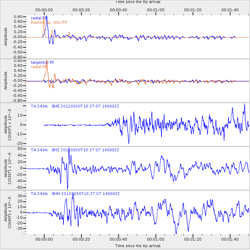
349A Repton, AL, USA - Earthquake Result Viewer
*The percent match for this event was below the threshold and hence no stack was calculated.
| Earthquake location: |
Colombia |
| Earthquake latitude/longitude: |
1.9/-76.4 |
| Earthquake time(UTC): |
2012/09/30 (274) 16:31:35 GMT |
| Earthquake Depth: |
170 km |
| Earthquake Magnitude: |
7.0 MB, 7.3 MW, 7.2 MW |
| Earthquake Catalog/Contributor: |
WHDF/NEIC |
|
| Network: |
TA USArray Transportable Network (new EarthScope stations) |
| Station: |
349A Repton, AL, USA |
| Lat/Lon: |
31.35 N/87.19 W |
| Elevation: |
88 m |
|
| Distance: |
31.0 deg |
| Az: |
341.813 deg |
| Baz: |
158.617 deg |
| Ray Param: |
$rayparam |
*The percent match for this event was below the threshold and hence was not used in the summary stack. |
|
| Radial Match: |
91.71545 % |
| Radial Bump: |
400 |
| Transverse Match: |
85.076805 % |
| Transverse Bump: |
400 |
| SOD ConfigId: |
478790 |
| Insert Time: |
2013-02-23 01:12:50.907 +0000 |
| GWidth: |
2.5 |
| Max Bumps: |
400 |
| Tol: |
0.001 |
|
Signal To Noise
| Channel | StoN | STA | LTA |
| TA:349A: :BHZ:20120930T16:37:07.149993Z | 22.004805 | 5.2271853E-6 | 2.3754745E-7 |
| TA:349A: :BHN:20120930T16:37:07.149993Z | 7.3353844 | 1.9079278E-6 | 2.6009923E-7 |
| TA:349A: :BHE:20120930T16:37:07.149993Z | 2.9134152 | 7.351733E-7 | 2.523407E-7 |
| Arrivals |
| Ps | |
| PpPs | |
| PsPs/PpSs | |


