You are here: Home > Network List > UU - University of Utah Regional Network Stations List
> Station ASI2 Darling Creek, Challis, ID, USA > Earthquake Result Viewer
ASI2 Darling Creek, Challis, ID, USA - Earthquake Result Viewer
| Earthquake location: |
Mexico-Guatemala Border Region |
| Earthquake latitude/longitude: |
15.3/-91.9 |
| Earthquake time(UTC): |
2014/06/16 (167) 10:04:30 GMT |
| Earthquake Depth: |
10 km |
| Earthquake Magnitude: |
5.0 MW |
| Earthquake Catalog/Contributor: |
ISC/ISC |
|
| Network: |
UU University of Utah Regional Network |
| Station: |
ASI2 Darling Creek, Challis, ID, USA |
| Lat/Lon: |
44.57 N/114.26 W |
| Elevation: |
1600 m |
|
| Distance: |
34.8 deg |
| Az: |
331.596 deg |
| Baz: |
140.035 deg |
| Ray Param: |
0.07756597 |
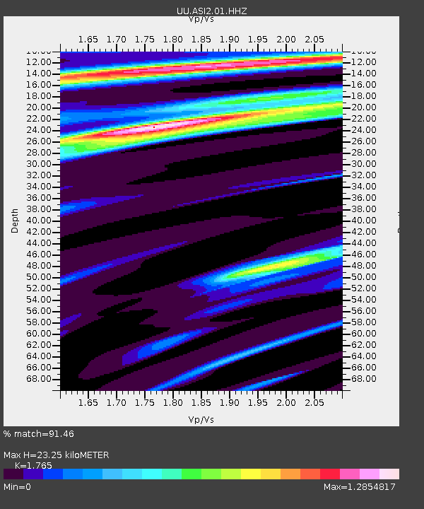
| Estimated Moho Depth: |
23.25 km |
| Estimated Crust Vp/Vs: |
1.76 |
| Assumed Crust Vp: |
6.577 km/s |
| Estimated Crust Vs: |
3.726 km/s |
| Estimated Crust Poisson's Ratio: |
0.26 |
|
| Radial Match: |
91.46 % |
| Radial Bump: |
275 |
| Transverse Match: |
81.22452 % |
| Transverse Bump: |
372 |
| SOD ConfigId: |
3390531 |
| Insert Time: |
2019-04-12 07:24:51.198 +0000 |
| GWidth: |
2.5 |
| Max Bumps: |
400 |
| Tol: |
0.001 |
|

Signal To Noise
| Channel | StoN | STA | LTA |
| UU:ASI2:01:HHZ:20140616T10:10:50.267988Z | 1.0166641 | 1.19177725E-8 | 1.1722428E-8 |
| UU:ASI2:01:HHN:20140616T10:10:50.267988Z | 0.8133219 | 6.4610615E-9 | 7.94404E-9 |
| UU:ASI2:01:HHE:20140616T10:10:50.267988Z | 0.5724919 | 7.791389E-9 | 1.3609606E-8 |
| Arrivals |
| Ps | 2.9 SECOND |
| PpPs | 9.0 SECOND |
| PsPs/PpSs | 12 SECOND |


