You are here: Home > Network List > TA - USArray Transportable Network (new EarthScope stations) Stations List
> Station 355A Pearson, GA, USA > Earthquake Result Viewer
355A Pearson, GA, USA - Earthquake Result Viewer
| Earthquake location: |
Colombia |
| Earthquake latitude/longitude: |
1.9/-76.4 |
| Earthquake time(UTC): |
2012/09/30 (274) 16:31:35 GMT |
| Earthquake Depth: |
170 km |
| Earthquake Magnitude: |
7.0 MB, 7.3 MW, 7.2 MW |
| Earthquake Catalog/Contributor: |
WHDF/NEIC |
|
| Network: |
TA USArray Transportable Network (new EarthScope stations) |
| Station: |
355A Pearson, GA, USA |
| Lat/Lon: |
31.34 N/82.85 W |
| Elevation: |
69 m |
|
| Distance: |
29.9 deg |
| Az: |
348.811 deg |
| Baz: |
166.9 deg |
| Ray Param: |
0.07916439 |
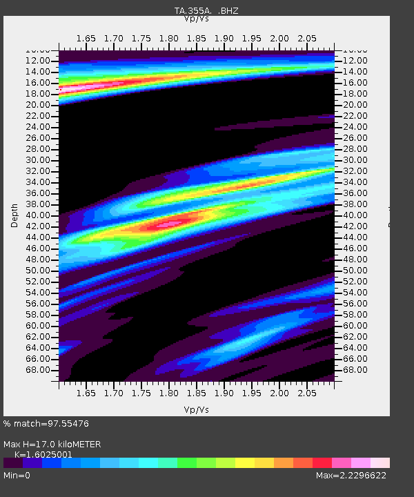
| Estimated Moho Depth: |
17.0 km |
| Estimated Crust Vp/Vs: |
1.60 |
| Assumed Crust Vp: |
6.565 km/s |
| Estimated Crust Vs: |
4.096 km/s |
| Estimated Crust Poisson's Ratio: |
0.18 |
|
| Radial Match: |
97.55476 % |
| Radial Bump: |
359 |
| Transverse Match: |
85.940735 % |
| Transverse Bump: |
400 |
| SOD ConfigId: |
478790 |
| Insert Time: |
2013-02-23 01:13:56.177 +0000 |
| GWidth: |
2.5 |
| Max Bumps: |
400 |
| Tol: |
0.001 |
|
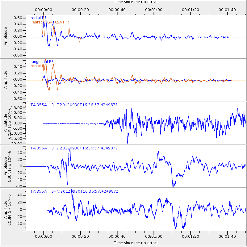
Signal To Noise
| Channel | StoN | STA | LTA |
| TA:355A: :BHZ:20120930T16:36:57.424987Z | 18.347158 | 4.479435E-6 | 2.441487E-7 |
| TA:355A: :BHN:20120930T16:36:57.424987Z | 13.598949 | 3.1472384E-6 | 2.3143247E-7 |
| TA:355A: :BHE:20120930T16:36:57.424987Z | 4.588271 | 6.965585E-7 | 1.5181284E-7 |
| Arrivals |
| Ps | 1.7 SECOND |
| PpPs | 6.1 SECOND |
| PsPs/PpSs | 7.9 SECOND |


