You are here: Home > Network List > TA - USArray Transportable Network (new EarthScope stations) Stations List
> Station Z53A Monticello, GA, USA > Earthquake Result Viewer
Z53A Monticello, GA, USA - Earthquake Result Viewer
| Earthquake location: |
Colombia |
| Earthquake latitude/longitude: |
1.9/-76.4 |
| Earthquake time(UTC): |
2012/09/30 (274) 16:31:35 GMT |
| Earthquake Depth: |
170 km |
| Earthquake Magnitude: |
7.0 MB, 7.3 MW, 7.2 MW |
| Earthquake Catalog/Contributor: |
WHDF/NEIC |
|
| Network: |
TA USArray Transportable Network (new EarthScope stations) |
| Station: |
Z53A Monticello, GA, USA |
| Lat/Lon: |
33.28 N/83.57 W |
| Elevation: |
144 m |
|
| Distance: |
31.9 deg |
| Az: |
348.529 deg |
| Baz: |
166.275 deg |
| Ray Param: |
0.07837493 |
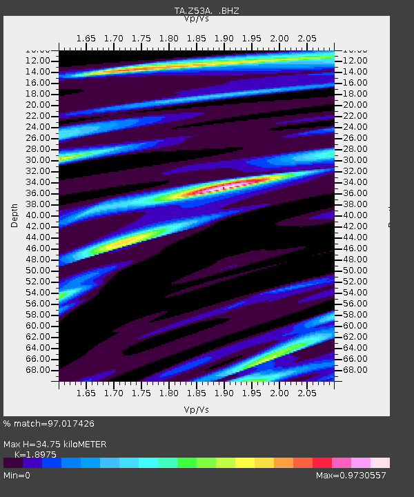
| Estimated Moho Depth: |
34.75 km |
| Estimated Crust Vp/Vs: |
1.90 |
| Assumed Crust Vp: |
6.565 km/s |
| Estimated Crust Vs: |
3.46 km/s |
| Estimated Crust Poisson's Ratio: |
0.31 |
|
| Radial Match: |
97.017426 % |
| Radial Bump: |
274 |
| Transverse Match: |
84.013565 % |
| Transverse Bump: |
400 |
| SOD ConfigId: |
478790 |
| Insert Time: |
2013-02-23 01:14:54.101 +0000 |
| GWidth: |
2.5 |
| Max Bumps: |
400 |
| Tol: |
0.001 |
|

Signal To Noise
| Channel | StoN | STA | LTA |
| TA:Z53A: :BHZ:20120930T16:37:15.100005Z | 39.29967 | 3.940164E-6 | 1.00259456E-7 |
| TA:Z53A: :BHN:20120930T16:37:15.100005Z | 22.040136 | 2.9551761E-6 | 1.3408157E-7 |
| TA:Z53A: :BHE:20120930T16:37:15.100005Z | 12.465643 | 1.0229804E-6 | 8.2063984E-8 |
| Arrivals |
| Ps | 5.1 SECOND |
| PpPs | 14 SECOND |
| PsPs/PpSs | 19 SECOND |


