You are here: Home > Network List > TA - USArray Transportable Network (new EarthScope stations) Stations List
> Station V52A Sevierville, TN, USA > Earthquake Result Viewer
V52A Sevierville, TN, USA - Earthquake Result Viewer
| Earthquake location: |
Colombia |
| Earthquake latitude/longitude: |
1.9/-76.4 |
| Earthquake time(UTC): |
2012/09/30 (274) 16:31:35 GMT |
| Earthquake Depth: |
170 km |
| Earthquake Magnitude: |
7.0 MB, 7.3 MW, 7.2 MW |
| Earthquake Catalog/Contributor: |
WHDF/NEIC |
|
| Network: |
TA USArray Transportable Network (new EarthScope stations) |
| Station: |
V52A Sevierville, TN, USA |
| Lat/Lon: |
35.84 N/83.60 W |
| Elevation: |
328 m |
|
| Distance: |
34.4 deg |
| Az: |
349.568 deg |
| Baz: |
167.13 deg |
| Ray Param: |
0.077169515 |
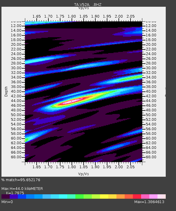
| Estimated Moho Depth: |
44.0 km |
| Estimated Crust Vp/Vs: |
1.80 |
| Assumed Crust Vp: |
6.35 km/s |
| Estimated Crust Vs: |
3.533 km/s |
| Estimated Crust Poisson's Ratio: |
0.28 |
|
| Radial Match: |
95.652176 % |
| Radial Bump: |
391 |
| Transverse Match: |
84.01664 % |
| Transverse Bump: |
400 |
| SOD ConfigId: |
478790 |
| Insert Time: |
2013-02-23 01:16:05.986 +0000 |
| GWidth: |
2.5 |
| Max Bumps: |
400 |
| Tol: |
0.001 |
|

Signal To Noise
| Channel | StoN | STA | LTA |
| TA:V52A: :BHZ:20120930T16:37:36.624999Z | 29.100864 | 4.85187E-6 | 1.6672598E-7 |
| TA:V52A: :BHN:20120930T16:37:36.624999Z | 30.595238 | 3.339414E-6 | 1.0914816E-7 |
| TA:V52A: :BHE:20120930T16:37:36.624999Z | 13.026135 | 1.1810369E-6 | 9.066672E-8 |
| Arrivals |
| Ps | 5.9 SECOND |
| PpPs | 18 SECOND |
| PsPs/PpSs | 24 SECOND |


