You are here: Home > Network List > TA - USArray Transportable Network (new EarthScope stations) Stations List
> Station R49A Shelbyville, KY, USA > Earthquake Result Viewer
R49A Shelbyville, KY, USA - Earthquake Result Viewer
| Earthquake location: |
Colombia |
| Earthquake latitude/longitude: |
1.9/-76.4 |
| Earthquake time(UTC): |
2012/09/30 (274) 16:31:35 GMT |
| Earthquake Depth: |
170 km |
| Earthquake Magnitude: |
7.0 MB, 7.3 MW, 7.2 MW |
| Earthquake Catalog/Contributor: |
WHDF/NEIC |
|
| Network: |
TA USArray Transportable Network (new EarthScope stations) |
| Station: |
R49A Shelbyville, KY, USA |
| Lat/Lon: |
38.29 N/85.17 W |
| Elevation: |
251 m |
|
| Distance: |
37.1 deg |
| Az: |
348.47 deg |
| Baz: |
165.293 deg |
| Ray Param: |
0.07571142 |
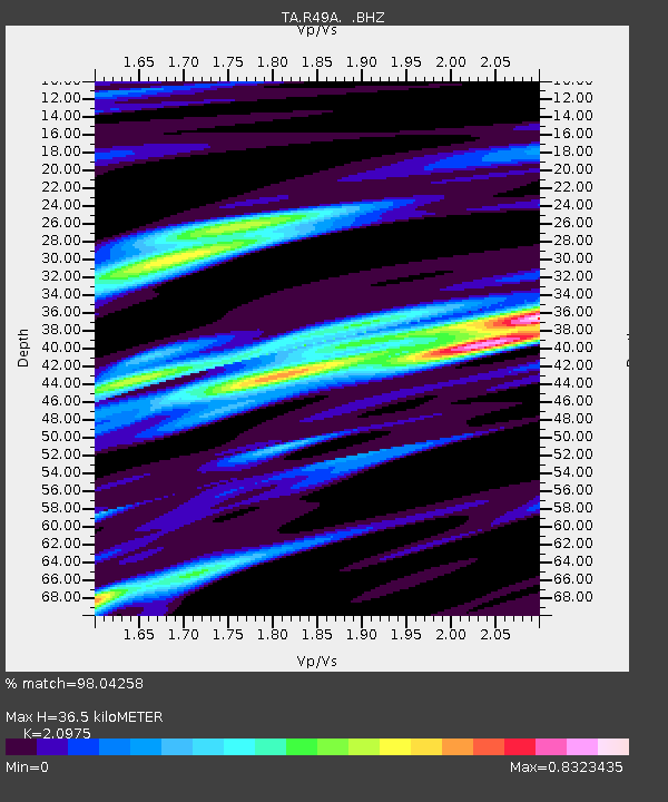
| Estimated Moho Depth: |
36.5 km |
| Estimated Crust Vp/Vs: |
2.10 |
| Assumed Crust Vp: |
6.498 km/s |
| Estimated Crust Vs: |
3.098 km/s |
| Estimated Crust Poisson's Ratio: |
0.35 |
|
| Radial Match: |
98.04258 % |
| Radial Bump: |
325 |
| Transverse Match: |
80.82113 % |
| Transverse Bump: |
400 |
| SOD ConfigId: |
478790 |
| Insert Time: |
2013-02-23 01:17:15.639 +0000 |
| GWidth: |
2.5 |
| Max Bumps: |
400 |
| Tol: |
0.001 |
|
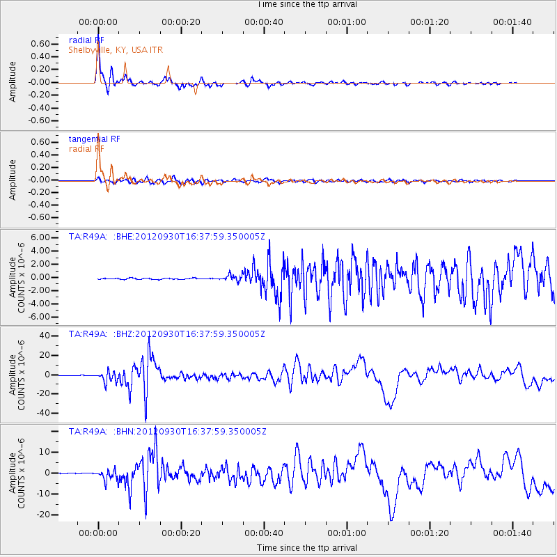
Signal To Noise
| Channel | StoN | STA | LTA |
| TA:R49A: :BHZ:20120930T16:37:59.350005Z | 49.29674 | 5.463316E-6 | 1.1082509E-7 |
| TA:R49A: :BHN:20120930T16:37:59.350005Z | 22.007114 | 2.591354E-6 | 1.1775073E-7 |
| TA:R49A: :BHE:20120930T16:37:59.350005Z | 5.1939692 | 4.7003394E-7 | 9.0496094E-8 |
| Arrivals |
| Ps | 6.6 SECOND |
| PpPs | 16 SECOND |
| PsPs/PpSs | 23 SECOND |


