You are here: Home > Network List > TA - USArray Transportable Network (new EarthScope stations) Stations List
> Station P50A Jamestown, OH, USA > Earthquake Result Viewer
P50A Jamestown, OH, USA - Earthquake Result Viewer
| Earthquake location: |
Colombia |
| Earthquake latitude/longitude: |
1.9/-76.4 |
| Earthquake time(UTC): |
2012/09/30 (274) 16:31:35 GMT |
| Earthquake Depth: |
170 km |
| Earthquake Magnitude: |
7.0 MB, 7.3 MW, 7.2 MW |
| Earthquake Catalog/Contributor: |
WHDF/NEIC |
|
| Network: |
TA USArray Transportable Network (new EarthScope stations) |
| Station: |
P50A Jamestown, OH, USA |
| Lat/Lon: |
39.61 N/83.80 W |
| Elevation: |
318 m |
|
| Distance: |
38.1 deg |
| Az: |
350.677 deg |
| Baz: |
167.901 deg |
| Ray Param: |
0.07512351 |
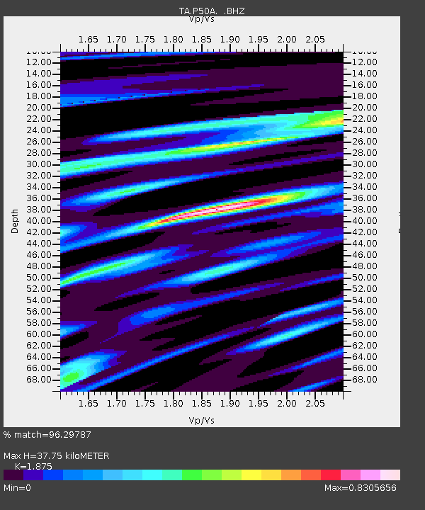
| Estimated Moho Depth: |
37.75 km |
| Estimated Crust Vp/Vs: |
1.88 |
| Assumed Crust Vp: |
6.232 km/s |
| Estimated Crust Vs: |
3.324 km/s |
| Estimated Crust Poisson's Ratio: |
0.30 |
|
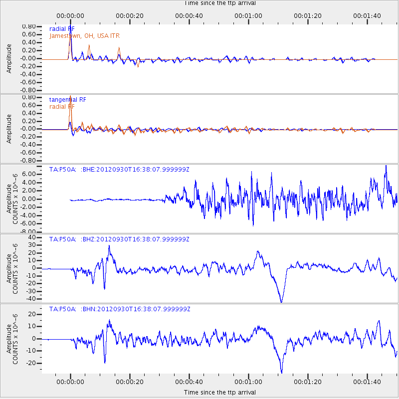
| Radial Match: |
96.29787 % |
| Radial Bump: |
400 |
| Transverse Match: |
84.08781 % |
| Transverse Bump: |
400 |
| SOD ConfigId: |
478790 |
| Insert Time: |
2013-02-23 01:17:38.419 +0000 |
| GWidth: |
2.5 |
| Max Bumps: |
400 |
| Tol: |
0.001 |
|
Signal To Noise
| Channel | StoN | STA | LTA |
| TA:P50A: :BHZ:20120930T16:38:07.999999Z | 23.45092 | 3.6906276E-6 | 1.5737668E-7 |
| TA:P50A: :BHN:20120930T16:38:07.999999Z | 19.771988 | 2.1482892E-6 | 1.0865317E-7 |
| TA:P50A: :BHE:20120930T16:38:07.999999Z | 3.6639452 | 4.234986E-7 | 1.1558541E-7 |
| Arrivals |
| Ps | 5.6 SECOND |
| PpPs | 16 SECOND |
| PsPs/PpSs | 22 SECOND |


