You are here: Home > Network List > TA - USArray Transportable Network (new EarthScope stations) Stations List
> Station O49A Covington, OH, USA > Earthquake Result Viewer
O49A Covington, OH, USA - Earthquake Result Viewer
| Earthquake location: |
Colombia |
| Earthquake latitude/longitude: |
1.9/-76.4 |
| Earthquake time(UTC): |
2012/09/30 (274) 16:31:35 GMT |
| Earthquake Depth: |
170 km |
| Earthquake Magnitude: |
7.0 MB, 7.3 MW, 7.2 MW |
| Earthquake Catalog/Contributor: |
WHDF/NEIC |
|
| Network: |
TA USArray Transportable Network (new EarthScope stations) |
| Station: |
O49A Covington, OH, USA |
| Lat/Lon: |
40.19 N/84.34 W |
| Elevation: |
292 m |
|
| Distance: |
38.8 deg |
| Az: |
350.229 deg |
| Baz: |
167.208 deg |
| Ray Param: |
0.074747376 |
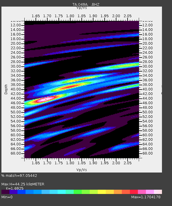
| Estimated Moho Depth: |
44.25 km |
| Estimated Crust Vp/Vs: |
1.69 |
| Assumed Crust Vp: |
6.498 km/s |
| Estimated Crust Vs: |
3.839 km/s |
| Estimated Crust Poisson's Ratio: |
0.23 |
|
| Radial Match: |
97.05442 % |
| Radial Bump: |
400 |
| Transverse Match: |
87.89418 % |
| Transverse Bump: |
400 |
| SOD ConfigId: |
478790 |
| Insert Time: |
2013-02-23 01:17:55.384 +0000 |
| GWidth: |
2.5 |
| Max Bumps: |
400 |
| Tol: |
0.001 |
|

Signal To Noise
| Channel | StoN | STA | LTA |
| TA:O49A: :BHZ:20120930T16:38:13.424987Z | 31.891096 | 5.004575E-6 | 1.5692703E-7 |
| TA:O49A: :BHN:20120930T16:38:13.424987Z | 25.439432 | 2.752593E-6 | 1.0820183E-7 |
| TA:O49A: :BHE:20120930T16:38:13.424987Z | 3.732265 | 5.1366476E-7 | 1.3762816E-7 |
| Arrivals |
| Ps | 5.1 SECOND |
| PpPs | 17 SECOND |
| PsPs/PpSs | 22 SECOND |


