You are here: Home > Network List > TA - USArray Transportable Network (new EarthScope stations) Stations List
> Station O52A Adamsville, OH, USA > Earthquake Result Viewer
O52A Adamsville, OH, USA - Earthquake Result Viewer
| Earthquake location: |
Colombia |
| Earthquake latitude/longitude: |
1.9/-76.4 |
| Earthquake time(UTC): |
2012/09/30 (274) 16:31:35 GMT |
| Earthquake Depth: |
170 km |
| Earthquake Magnitude: |
7.0 MB, 7.3 MW, 7.2 MW |
| Earthquake Catalog/Contributor: |
WHDF/NEIC |
|
| Network: |
TA USArray Transportable Network (new EarthScope stations) |
| Station: |
O52A Adamsville, OH, USA |
| Lat/Lon: |
40.12 N/81.84 W |
| Elevation: |
331 m |
|
| Distance: |
38.3 deg |
| Az: |
353.226 deg |
| Baz: |
171.158 deg |
| Ray Param: |
0.07499604 |
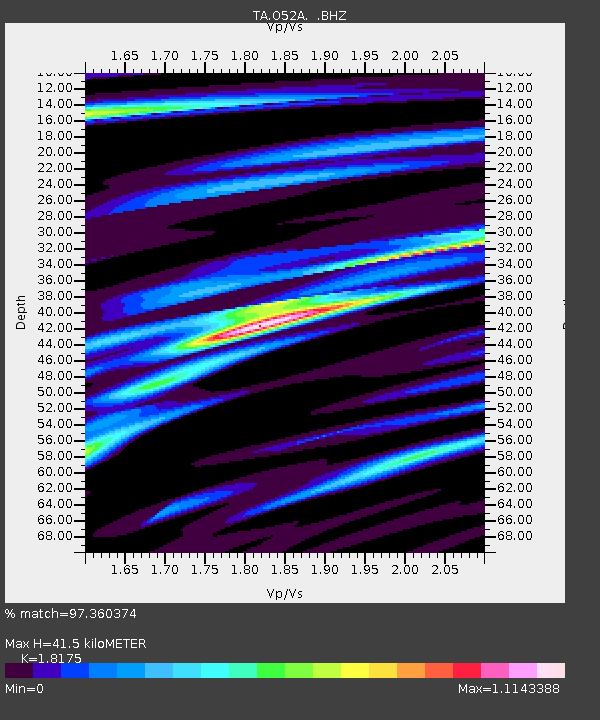
| Estimated Moho Depth: |
41.5 km |
| Estimated Crust Vp/Vs: |
1.82 |
| Assumed Crust Vp: |
6.483 km/s |
| Estimated Crust Vs: |
3.567 km/s |
| Estimated Crust Poisson's Ratio: |
0.28 |
|
| Radial Match: |
97.360374 % |
| Radial Bump: |
370 |
| Transverse Match: |
88.75259 % |
| Transverse Bump: |
400 |
| SOD ConfigId: |
478790 |
| Insert Time: |
2013-02-23 01:19:22.181 +0000 |
| GWidth: |
2.5 |
| Max Bumps: |
400 |
| Tol: |
0.001 |
|

Signal To Noise
| Channel | StoN | STA | LTA |
| TA:O52A: :BHZ:20120930T16:38:09.850005Z | 44.755993 | 6.8504396E-6 | 1.5306196E-7 |
| TA:O52A: :BHN:20120930T16:38:09.850005Z | 17.358356 | 3.233038E-6 | 1.8625254E-7 |
| TA:O52A: :BHE:20120930T16:38:09.850005Z | 6.369886 | 5.737684E-7 | 9.007515E-8 |
| Arrivals |
| Ps | 5.6 SECOND |
| PpPs | 17 SECOND |
| PsPs/PpSs | 22 SECOND |


