You are here: Home > Network List > G - GEOSCOPE Stations List
> Station WUS Wushi, Xinjiang Uygur, China > Earthquake Result Viewer
WUS Wushi, Xinjiang Uygur, China - Earthquake Result Viewer
| Earthquake location: |
Irian Jaya Region, Indonesia |
| Earthquake latitude/longitude: |
-3.1/136.0 |
| Earthquake time(UTC): |
1994/04/13 (103) 22:22:29 GMT |
| Earthquake Depth: |
20 km |
| Earthquake Magnitude: |
6.0 MB, 6.5 MS, 6.5 UNKNOWN, 6.5 MW |
| Earthquake Catalog/Contributor: |
WHDF/NEIC |
|
| Network: |
G GEOSCOPE |
| Station: |
WUS Wushi, Xinjiang Uygur, China |
| Lat/Lon: |
41.20 N/79.22 E |
| Elevation: |
1457 m |
|
| Distance: |
67.8 deg |
| Az: |
317.032 deg |
| Baz: |
115.588 deg |
| Ray Param: |
0.056699645 |
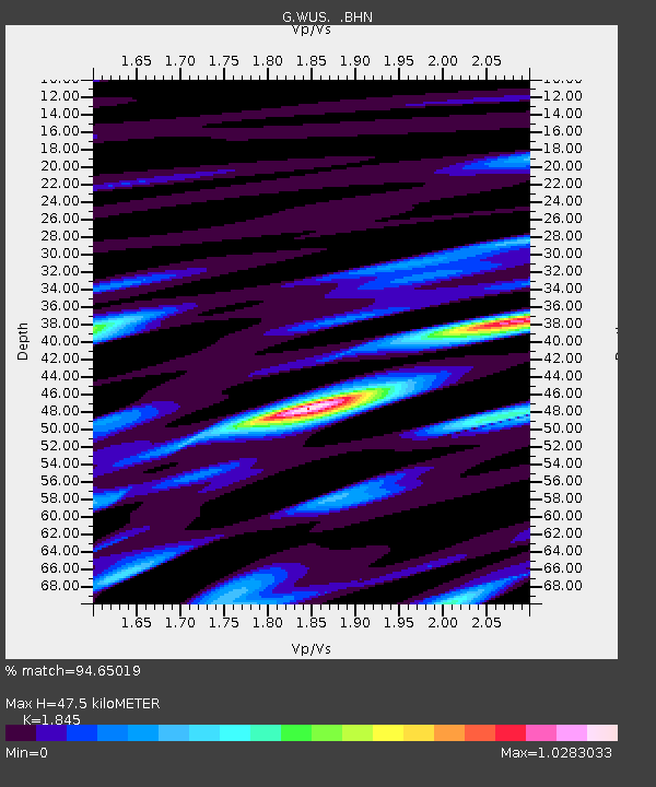
| Estimated Moho Depth: |
47.5 km |
| Estimated Crust Vp/Vs: |
1.85 |
| Assumed Crust Vp: |
6.353 km/s |
| Estimated Crust Vs: |
3.443 km/s |
| Estimated Crust Poisson's Ratio: |
0.29 |
|
| Radial Match: |
94.65019 % |
| Radial Bump: |
400 |
| Transverse Match: |
89.832054 % |
| Transverse Bump: |
400 |
| SOD ConfigId: |
16938 |
| Insert Time: |
2010-02-27 00:53:03.846 +0000 |
| GWidth: |
2.5 |
| Max Bumps: |
400 |
| Tol: |
0.001 |
|

Signal To Noise
| Channel | StoN | STA | LTA |
| G:WUS: :BHN:19940413T22:32:54.299011Z | 1.132276 | 1.0249613E-7 | 9.0522214E-8 |
| G:WUS: :BHE:19940413T22:32:54.299011Z | 3.141719 | 1.3212183E-7 | 4.205399E-8 |
| G:WUS: :BHZ:19940413T22:32:54.299011Z | 5.7452908 | 4.4181022E-7 | 7.689954E-8 |
| Arrivals |
| Ps | 6.6 SECOND |
| PpPs | 21 SECOND |
| PsPs/PpSs | 27 SECOND |


