You are here: Home > Network List > G - GEOSCOPE Stations List
> Station WUS Wushi, Xinjiang Uygur, China > Earthquake Result Viewer
WUS Wushi, Xinjiang Uygur, China - Earthquake Result Viewer
| Earthquake location: |
Taiwan Region |
| Earthquake latitude/longitude: |
24.0/122.5 |
| Earthquake time(UTC): |
1994/05/24 (144) 04:00:46 GMT |
| Earthquake Depth: |
47 km |
| Earthquake Magnitude: |
6.0 MB, 6.6 MS, 6.3 UNKNOWN, 6.5 MW |
| Earthquake Catalog/Contributor: |
WHDF/NEIC |
|
| Network: |
G GEOSCOPE |
| Station: |
WUS Wushi, Xinjiang Uygur, China |
| Lat/Lon: |
41.20 N/79.22 E |
| Elevation: |
1457 m |
|
| Distance: |
39.9 deg |
| Az: |
306.185 deg |
| Baz: |
101.898 deg |
| Ray Param: |
0.07459747 |
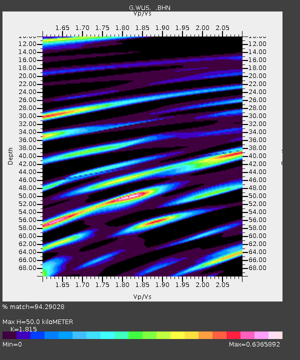
| Estimated Moho Depth: |
50.0 km |
| Estimated Crust Vp/Vs: |
1.82 |
| Assumed Crust Vp: |
6.353 km/s |
| Estimated Crust Vs: |
3.5 km/s |
| Estimated Crust Poisson's Ratio: |
0.28 |
|
| Radial Match: |
94.29028 % |
| Radial Bump: |
400 |
| Transverse Match: |
79.265945 % |
| Transverse Bump: |
400 |
| SOD ConfigId: |
16938 |
| Insert Time: |
2010-02-27 00:53:06.454 +0000 |
| GWidth: |
2.5 |
| Max Bumps: |
400 |
| Tol: |
0.001 |
|

Signal To Noise
| Channel | StoN | STA | LTA |
| G:WUS: :BHN:19940524T04:07:45.150006Z | 1.538049 | 9.2637684E-8 | 6.023065E-8 |
| G:WUS: :BHE:19940524T04:07:45.150006Z | 3.6885579 | 1.7710907E-7 | 4.8015803E-8 |
| G:WUS: :BHZ:19940524T04:07:45.150006Z | 3.019832 | 2.0385222E-7 | 6.7504494E-8 |
| Arrivals |
| Ps | 6.9 SECOND |
| PpPs | 21 SECOND |
| PsPs/PpSs | 28 SECOND |


