You are here: Home > Network List > UW - Pacific Northwest Regional Seismic Network Stations List
> Station HOOD Mt Hood Meadows, OR CREST BB SMO > Earthquake Result Viewer
HOOD Mt Hood Meadows, OR CREST BB SMO - Earthquake Result Viewer
| Earthquake location: |
Colombia |
| Earthquake latitude/longitude: |
1.9/-76.4 |
| Earthquake time(UTC): |
2012/09/30 (274) 16:31:35 GMT |
| Earthquake Depth: |
170 km |
| Earthquake Magnitude: |
7.0 MB, 7.3 MW, 7.2 MW |
| Earthquake Catalog/Contributor: |
WHDF/NEIC |
|
| Network: |
UW Pacific Northwest Regional Seismic Network |
| Station: |
HOOD Mt Hood Meadows, OR CREST BB SMO |
| Lat/Lon: |
45.32 N/121.65 W |
| Elevation: |
1520 m |
|
| Distance: |
58.7 deg |
| Az: |
324.062 deg |
| Baz: |
123.755 deg |
| Ray Param: |
0.06213998 |
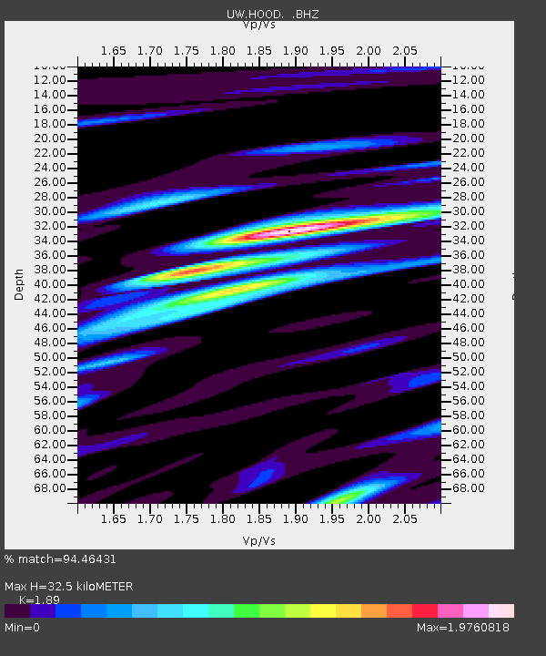
| Estimated Moho Depth: |
32.5 km |
| Estimated Crust Vp/Vs: |
1.89 |
| Assumed Crust Vp: |
6.597 km/s |
| Estimated Crust Vs: |
3.491 km/s |
| Estimated Crust Poisson's Ratio: |
0.31 |
|
| Radial Match: |
94.46431 % |
| Radial Bump: |
400 |
| Transverse Match: |
90.300705 % |
| Transverse Bump: |
400 |
| SOD ConfigId: |
478790 |
| Insert Time: |
2013-02-23 01:22:06.704 +0000 |
| GWidth: |
2.5 |
| Max Bumps: |
400 |
| Tol: |
0.001 |
|

Signal To Noise
| Channel | StoN | STA | LTA |
| UW:HOOD: :BHZ:20120930T16:40:44.845Z | 34.32538 | 6.8732893E-6 | 2.0023928E-7 |
| UW:HOOD: :BHN:20120930T16:40:44.845Z | 5.25876 | 1.4082519E-6 | 2.6779162E-7 |
| UW:HOOD: :BHE:20120930T16:40:44.845Z | 13.6201315 | 3.0362303E-6 | 2.2292224E-7 |
| Arrivals |
| Ps | 4.6 SECOND |
| PpPs | 14 SECOND |
| PsPs/PpSs | 18 SECOND |


