You are here: Home > Network List > KN - Kyrgyz Seismic Telemetry Network Stations List
> Station TKM2 - > Earthquake Result Viewer
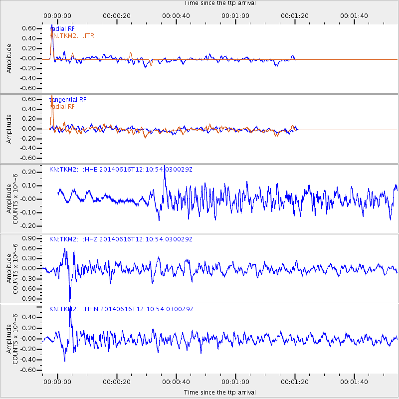
TKM2 - - Earthquake Result Viewer
*The percent match for this event was below the threshold and hence no stack was calculated.
| Earthquake location: |
Northern Alaska |
| Earthquake latitude/longitude: |
67.7/-162.0 |
| Earthquake time(UTC): |
2014/06/16 (167) 12:01:11 GMT |
| Earthquake Depth: |
16 km |
| Earthquake Magnitude: |
5.7 MB, 5.5 MWP, 5.5 MI |
| Earthquake Catalog/Contributor: |
NEIC PDE/NEIC COMCAT |
|
| Network: |
KN Kyrgyz Seismic Telemetry Network |
| Station: |
TKM2 - |
| Lat/Lon: |
42.92 N/75.60 E |
| Elevation: |
2020 m |
|
| Distance: |
61.5 deg |
| Az: |
315.12 deg |
| Baz: |
21.505 deg |
| Ray Param: |
$rayparam |
*The percent match for this event was below the threshold and hence was not used in the summary stack. |
|
| Radial Match: |
78.9864 % |
| Radial Bump: |
400 |
| Transverse Match: |
66.38538 % |
| Transverse Bump: |
400 |
| SOD ConfigId: |
3390531 |
| Insert Time: |
2019-04-12 07:28:50.817 +0000 |
| GWidth: |
2.5 |
| Max Bumps: |
400 |
| Tol: |
0.001 |
|
Signal To Noise
| Channel | StoN | STA | LTA |
| KN:TKM2: :HHZ:20140616T12:10:54.030029Z | 8.042675 | 3.5302236E-7 | 4.389365E-8 |
| KN:TKM2: :HHN:20140616T12:10:54.030029Z | 9.0583 | 2.2652081E-7 | 2.5006988E-8 |
| KN:TKM2: :HHE:20140616T12:10:54.030029Z | 3.299026 | 8.5043645E-8 | 2.5778409E-8 |
| Arrivals |
| Ps | |
| PpPs | |
| PsPs/PpSs | |


