You are here: Home > Network List > UW - Pacific Northwest Regional Seismic Network Stations List
> Station LEBA Lebam, WA, USA > Earthquake Result Viewer
LEBA Lebam, WA, USA - Earthquake Result Viewer
| Earthquake location: |
Colombia |
| Earthquake latitude/longitude: |
1.9/-76.4 |
| Earthquake time(UTC): |
2012/09/30 (274) 16:31:35 GMT |
| Earthquake Depth: |
170 km |
| Earthquake Magnitude: |
7.0 MB, 7.3 MW, 7.2 MW |
| Earthquake Catalog/Contributor: |
WHDF/NEIC |
|
| Network: |
UW Pacific Northwest Regional Seismic Network |
| Station: |
LEBA Lebam, WA, USA |
| Lat/Lon: |
46.55 N/123.56 W |
| Elevation: |
73 m |
|
| Distance: |
60.5 deg |
| Az: |
324.406 deg |
| Baz: |
122.561 deg |
| Ray Param: |
0.06097806 |
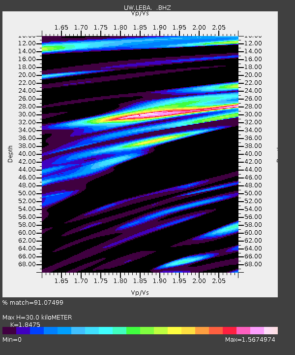
| Estimated Moho Depth: |
30.0 km |
| Estimated Crust Vp/Vs: |
1.85 |
| Assumed Crust Vp: |
6.566 km/s |
| Estimated Crust Vs: |
3.554 km/s |
| Estimated Crust Poisson's Ratio: |
0.29 |
|
| Radial Match: |
91.07499 % |
| Radial Bump: |
400 |
| Transverse Match: |
76.80075 % |
| Transverse Bump: |
400 |
| SOD ConfigId: |
478790 |
| Insert Time: |
2013-02-23 01:22:41.874 +0000 |
| GWidth: |
2.5 |
| Max Bumps: |
400 |
| Tol: |
0.001 |
|
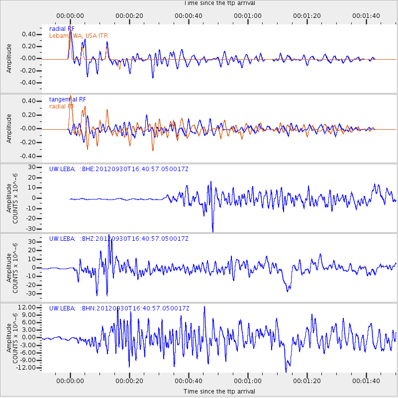
Signal To Noise
| Channel | StoN | STA | LTA |
| UW:LEBA: :BHZ:20120930T16:40:57.050017Z | 15.668017 | 4.9695336E-6 | 3.1717693E-7 |
| UW:LEBA: :BHN:20120930T16:40:57.050017Z | 1.6117288 | 6.4441264E-7 | 3.9982697E-7 |
| UW:LEBA: :BHE:20120930T16:40:57.050017Z | 4.6045265 | 1.7401319E-6 | 3.7791767E-7 |
| Arrivals |
| Ps | 4.1 SECOND |
| PpPs | 12 SECOND |
| PsPs/PpSs | 16 SECOND |


