You are here: Home > Network List > UW - Pacific Northwest Regional Seismic Network Stations List
> Station RADR Rader Ridge, WA > Earthquake Result Viewer
RADR Rader Ridge, WA - Earthquake Result Viewer
| Earthquake location: |
Colombia |
| Earthquake latitude/longitude: |
1.9/-76.4 |
| Earthquake time(UTC): |
2012/09/30 (274) 16:31:35 GMT |
| Earthquake Depth: |
170 km |
| Earthquake Magnitude: |
7.0 MB, 7.3 MW, 7.2 MW |
| Earthquake Catalog/Contributor: |
WHDF/NEIC |
|
| Network: |
UW Pacific Northwest Regional Seismic Network |
| Station: |
RADR Rader Ridge, WA |
| Lat/Lon: |
46.42 N/123.80 W |
| Elevation: |
568 m |
|
| Distance: |
60.5 deg |
| Az: |
324.185 deg |
| Baz: |
122.282 deg |
| Ray Param: |
0.060931668 |
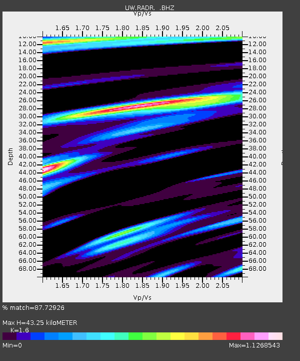
| Estimated Moho Depth: |
43.25 km |
| Estimated Crust Vp/Vs: |
1.60 |
| Assumed Crust Vp: |
6.566 km/s |
| Estimated Crust Vs: |
4.104 km/s |
| Estimated Crust Poisson's Ratio: |
0.18 |
|
| Radial Match: |
87.72926 % |
| Radial Bump: |
400 |
| Transverse Match: |
85.31825 % |
| Transverse Bump: |
400 |
| SOD ConfigId: |
478790 |
| Insert Time: |
2013-02-23 01:23:41.156 +0000 |
| GWidth: |
2.5 |
| Max Bumps: |
400 |
| Tol: |
0.001 |
|

Signal To Noise
| Channel | StoN | STA | LTA |
| UW:RADR: :BHZ:20120930T16:40:57.514983Z | 14.540362 | 5.8450437E-6 | 4.0198748E-7 |
| UW:RADR: :BHN:20120930T16:40:57.514983Z | 2.4703777 | 1.5803104E-6 | 6.397039E-7 |
| UW:RADR: :BHE:20120930T16:40:57.514983Z | 5.7003145 | 3.0278873E-6 | 5.3117896E-7 |
| Arrivals |
| Ps | 4.2 SECOND |
| PpPs | 16 SECOND |
| PsPs/PpSs | 20 SECOND |


