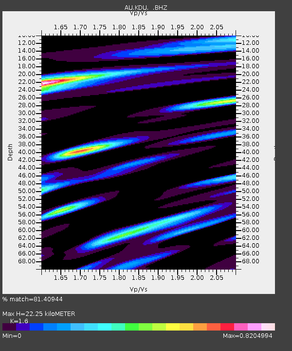
KDU Kakadu, NT - Earthquake Result Viewer

Earthquake location: Off East Coast Of Honshu, Japan
Earthquake latitude/longitude: 39.8/143.1
Earthquake time(UTC): 2012/10/01 (275) 22:21:46 GMT
Earthquake Depth: 15 km
Earthquake Magnitude: 5.6 MB, 5.7 MS, 6.1 MW, 6.0 MW
Earthquake Catalog/Contributor: WHDF/NEIC
Network: AU Australian Seismological Centre
Station: KDU Kakadu, NT
Lat/Lon: 12.69 S/132.47 E
Elevation: 46 m
Distance: 53.2 deg
Az: 192.996 deg
Baz: 10.225 deg
Ray Param: 0.06627902
Estimated Moho Depth: 22.25 km
Estimated Crust Vp/Vs: 1.60
Assumed Crust Vp: 6.61 km/s
Estimated Crust Vs: 4.131 km/s
Estimated Crust Poisson's Ratio: 0.18
Radial Match: 81.40944 %
Radial Bump: 395
Transverse Match: 68.84038 %
Transverse Bump: 400
SOD ConfigId: 478790
Insert Time: 2013-02-23 01:27:44.411 +0000
GWidth: 2.5
Max Bumps: 400
Tol: 0.001

Signal To Noise

ChannelStoNSTALTA
AU:KDU: :BHZ:20121001T22:30:32.145Z3.2467424.352361E-71.3405318E-7
AU:KDU: :BHN:20121001T22:30:32.145Z2.48674133.0152688E-71.2125382E-7
AU:KDU: :BHE:20121001T22:30:32.145Z0.91438721.2098658E-71.3231438E-7
Arrivals
Ps2.2 SECOND
PpPs8.2 SECOND
PsPs/PpSs10 SECOND