You are here: Home > Network List > G - GEOSCOPE Stations List
> Station WUS Wushi, Xinjiang Uygur, China > Earthquake Result Viewer
WUS Wushi, Xinjiang Uygur, China - Earthquake Result Viewer
| Earthquake location: |
Kuril Islands |
| Earthquake latitude/longitude: |
44.7/149.1 |
| Earthquake time(UTC): |
1994/08/20 (232) 04:38:51 GMT |
| Earthquake Depth: |
33 km |
| Earthquake Magnitude: |
6.1 MB, 6.0 MS, 5.7 UNKNOWN, 6.3 MW |
| Earthquake Catalog/Contributor: |
WHDF/NEIC |
|
| Network: |
G GEOSCOPE |
| Station: |
WUS Wushi, Xinjiang Uygur, China |
| Lat/Lon: |
41.20 N/79.22 E |
| Elevation: |
1457 m |
|
| Distance: |
49.9 deg |
| Az: |
292.019 deg |
| Baz: |
61.224 deg |
| Ray Param: |
0.06836782 |
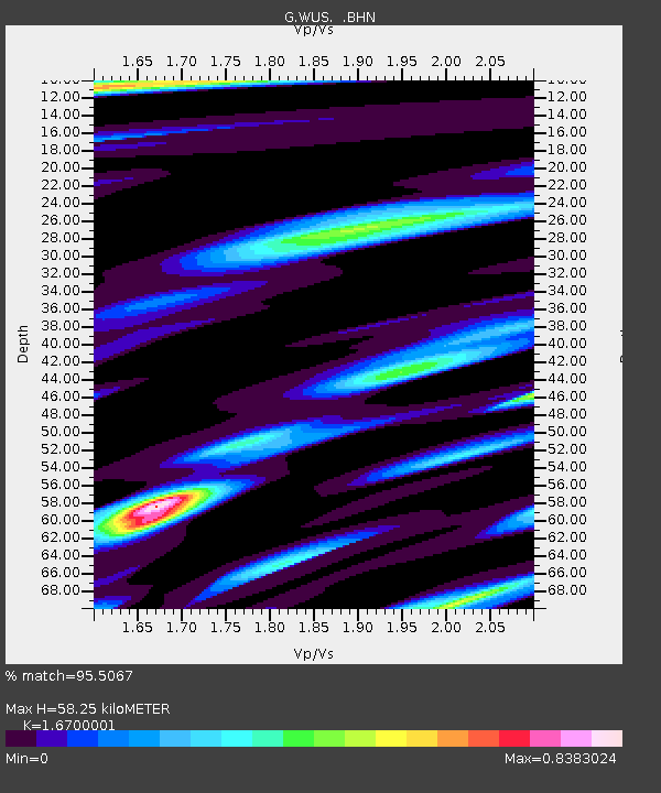
| Estimated Moho Depth: |
58.25 km |
| Estimated Crust Vp/Vs: |
1.67 |
| Assumed Crust Vp: |
6.353 km/s |
| Estimated Crust Vs: |
3.804 km/s |
| Estimated Crust Poisson's Ratio: |
0.22 |
|
| Radial Match: |
95.5067 % |
| Radial Bump: |
400 |
| Transverse Match: |
88.37304 % |
| Transverse Bump: |
400 |
| SOD ConfigId: |
16938 |
| Insert Time: |
2010-02-27 00:53:26.725 +0000 |
| GWidth: |
2.5 |
| Max Bumps: |
400 |
| Tol: |
0.001 |
|

Signal To Noise
| Channel | StoN | STA | LTA |
| G:WUS: :BHN:19940820T04:47:11.050012Z | 8.768634 | 4.33537E-7 | 4.9441795E-8 |
| G:WUS: :BHE:19940820T04:47:11.050012Z | 16.635866 | 6.0828745E-7 | 3.6564817E-8 |
| G:WUS: :BHZ:19940820T04:47:11.050012Z | 39.366787 | 1.6046403E-6 | 4.076127E-8 |
| Arrivals |
| Ps | 6.5 SECOND |
| PpPs | 23 SECOND |
| PsPs/PpSs | 30 SECOND |


