You are here: Home > Network List > CN - Canadian National Seismograph Network Stations List
> Station INK INUVIK, NT > Earthquake Result Viewer
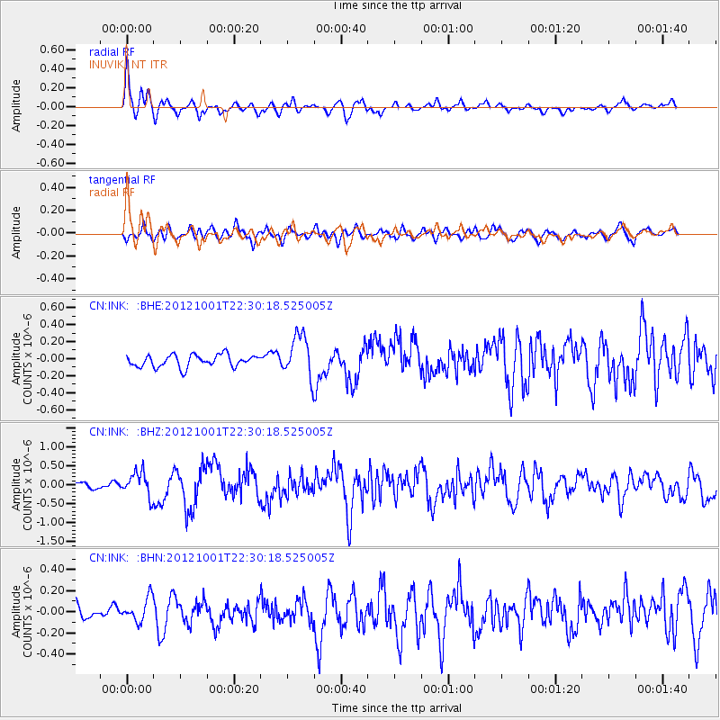
INK INUVIK, NT - Earthquake Result Viewer
*The percent match for this event was below the threshold and hence no stack was calculated.
| Earthquake location: |
Off East Coast Of Honshu, Japan |
| Earthquake latitude/longitude: |
39.8/143.1 |
| Earthquake time(UTC): |
2012/10/01 (275) 22:21:46 GMT |
| Earthquake Depth: |
15 km |
| Earthquake Magnitude: |
5.6 MB, 5.7 MS, 6.1 MW, 6.0 MW |
| Earthquake Catalog/Contributor: |
WHDF/NEIC |
|
| Network: |
CN Canadian National Seismograph Network |
| Station: |
INK INUVIK, NT |
| Lat/Lon: |
68.31 N/133.53 W |
| Elevation: |
44 m |
|
| Distance: |
51.3 deg |
| Az: |
28.235 deg |
| Baz: |
281.422 deg |
| Ray Param: |
$rayparam |
*The percent match for this event was below the threshold and hence was not used in the summary stack. |
|
| Radial Match: |
79.53023 % |
| Radial Bump: |
400 |
| Transverse Match: |
56.734554 % |
| Transverse Bump: |
400 |
| SOD ConfigId: |
478790 |
| Insert Time: |
2013-02-23 01:29:30.682 +0000 |
| GWidth: |
2.5 |
| Max Bumps: |
400 |
| Tol: |
0.001 |
|
Signal To Noise
| Channel | StoN | STA | LTA |
| CN:INK: :BHZ:20121001T22:30:18.525005Z | 3.576371 | 3.2190212E-7 | 9.000804E-8 |
| CN:INK: :BHN:20121001T22:30:18.525005Z | 1.2487972 | 1.1372144E-7 | 9.106478E-8 |
| CN:INK: :BHE:20121001T22:30:18.525005Z | 3.5047364 | 2.5278968E-7 | 7.212801E-8 |
| Arrivals |
| Ps | |
| PpPs | |
| PsPs/PpSs | |


