You are here: Home > Network List > UW - Pacific Northwest Regional Seismic Network Stations List
> Station WOLL Wollman Farm, Schrag, WA, USA > Earthquake Result Viewer
WOLL Wollman Farm, Schrag, WA, USA - Earthquake Result Viewer

| Earthquake location: |
Northern Alaska |
| Earthquake latitude/longitude: |
67.7/-162.0 |
| Earthquake time(UTC): |
2014/06/16 (167) 12:01:11 GMT |
| Earthquake Depth: |
16 km |
| Earthquake Magnitude: |
5.7 MB, 5.5 MWP, 5.5 MI |
| Earthquake Catalog/Contributor: |
NEIC PDE/NEIC COMCAT |
|
| Network: |
UW Pacific Northwest Regional Seismic Network |
| Station: |
WOLL Wollman Farm, Schrag, WA, USA |
| Lat/Lon: |
47.06 N/118.92 W |
| Elevation: |
385 m |
|
| Distance: |
30.1 deg |
| Az: |
111.412 deg |
| Baz: |
328.693 deg |
| Ray Param: |
0.07941191 |
| Estimated Moho Depth: |
13.75 km |
| Estimated Crust Vp/Vs: |
1.60 |
| Assumed Crust Vp: |
6.419 km/s |
| Estimated Crust Vs: |
4.012 km/s |
| Estimated Crust Poisson's Ratio: |
0.18 |
|
| Radial Match: |
90.37978 % |
| Radial Bump: |
263 |
| Transverse Match: |
65.495094 % |
| Transverse Bump: |
400 |
| SOD ConfigId: |
3390531 |
| Insert Time: |
2019-04-12 07:32:11.776 +0000 |
| GWidth: |
2.5 |
| Max Bumps: |
400 |
| Tol: |
0.001 |
|
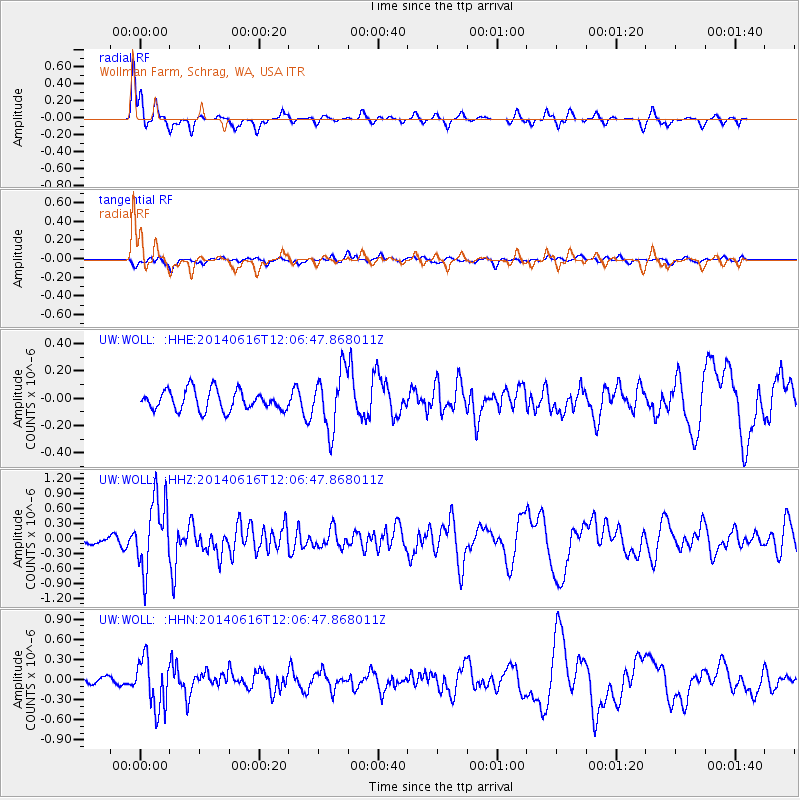
Signal To Noise
| Channel | StoN | STA | LTA |
| UW:WOLL: :HHZ:20140616T12:06:47.868011Z | 8.296915 | 7.109219E-7 | 8.568509E-8 |
| UW:WOLL: :HHN:20140616T12:06:47.868011Z | 7.8322387 | 3.7570243E-7 | 4.7968715E-8 |
| UW:WOLL: :HHE:20140616T12:06:47.868011Z | 3.1260614 | 2.3403501E-7 | 7.4865774E-8 |
| Arrivals |
| Ps | 1.4 SECOND |
| PpPs | 5.1 SECOND |
| PsPs/PpSs | 6.5 SECOND |


