You are here: Home > Network List > G - GEOSCOPE Stations List
> Station WUS Wushi, Xinjiang Uygur, China > Earthquake Result Viewer
WUS Wushi, Xinjiang Uygur, China - Earthquake Result Viewer
| Earthquake location: |
Lake Tanganyika Region |
| Earthquake latitude/longitude: |
-7.3/31.8 |
| Earthquake time(UTC): |
1994/08/18 (230) 00:45:48 GMT |
| Earthquake Depth: |
29 km |
| Earthquake Magnitude: |
6.0 MB, 5.8 MS, 6.1 UNKNOWN, 5.9 MW |
| Earthquake Catalog/Contributor: |
WHDF/NEIC |
|
| Network: |
G GEOSCOPE |
| Station: |
WUS Wushi, Xinjiang Uygur, China |
| Lat/Lon: |
41.20 N/79.22 E |
| Elevation: |
1457 m |
|
| Distance: |
65.0 deg |
| Az: |
37.829 deg |
| Baz: |
233.723 deg |
| Ray Param: |
0.058536433 |
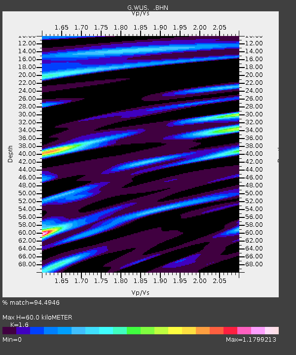
| Estimated Moho Depth: |
60.0 km |
| Estimated Crust Vp/Vs: |
1.60 |
| Assumed Crust Vp: |
6.353 km/s |
| Estimated Crust Vs: |
3.971 km/s |
| Estimated Crust Poisson's Ratio: |
0.18 |
|
| Radial Match: |
94.4946 % |
| Radial Bump: |
400 |
| Transverse Match: |
82.73927 % |
| Transverse Bump: |
400 |
| SOD ConfigId: |
17000 |
| Insert Time: |
2010-02-27 00:53:38.805 +0000 |
| GWidth: |
2.5 |
| Max Bumps: |
400 |
| Tol: |
0.001 |
|

Signal To Noise
| Channel | StoN | STA | LTA |
| G:WUS: :BHN:19940818T00:55:54.150024Z | 2.3166616 | 8.746625E-8 | 3.7755296E-8 |
| G:WUS: :BHE:19940818T00:55:54.150024Z | 3.4363773 | 1.207316E-7 | 3.5133393E-8 |
| G:WUS: :BHZ:19940818T00:55:54.150024Z | 9.284081 | 4.154519E-7 | 4.474884E-8 |
| Arrivals |
| Ps | 5.9 SECOND |
| PpPs | 23 SECOND |
| PsPs/PpSs | 29 SECOND |


