You are here: Home > Network List > TA - USArray Transportable Network (new EarthScope stations) Stations List
> Station P42A Winchester, IL, USA > Earthquake Result Viewer
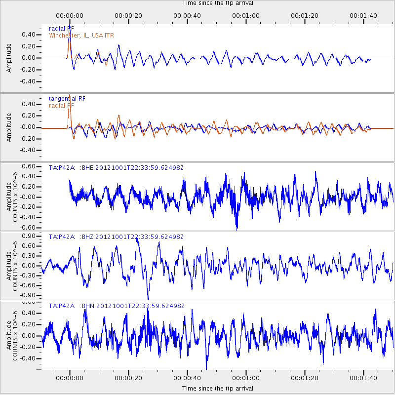
P42A Winchester, IL, USA - Earthquake Result Viewer
*The percent match for this event was below the threshold and hence no stack was calculated.
| Earthquake location: |
Off East Coast Of Honshu, Japan |
| Earthquake latitude/longitude: |
39.8/143.1 |
| Earthquake time(UTC): |
2012/10/01 (275) 22:21:46 GMT |
| Earthquake Depth: |
15 km |
| Earthquake Magnitude: |
5.6 MB, 5.7 MS, 6.1 MW, 6.0 MW |
| Earthquake Catalog/Contributor: |
WHDF/NEIC |
|
| Network: |
TA USArray Transportable Network (new EarthScope stations) |
| Station: |
P42A Winchester, IL, USA |
| Lat/Lon: |
39.59 N/90.34 W |
| Elevation: |
197 m |
|
| Distance: |
87.1 deg |
| Az: |
38.428 deg |
| Baz: |
321.717 deg |
| Ray Param: |
$rayparam |
*The percent match for this event was below the threshold and hence was not used in the summary stack. |
|
| Radial Match: |
74.639435 % |
| Radial Bump: |
400 |
| Transverse Match: |
61.593773 % |
| Transverse Bump: |
400 |
| SOD ConfigId: |
478790 |
| Insert Time: |
2013-02-23 01:36:11.018 +0000 |
| GWidth: |
2.5 |
| Max Bumps: |
400 |
| Tol: |
0.001 |
|
Signal To Noise
| Channel | StoN | STA | LTA |
| TA:P42A: :BHZ:20121001T22:33:59.62498Z | 2.4368916 | 2.601259E-7 | 1.06744956E-7 |
| TA:P42A: :BHN:20121001T22:33:59.62498Z | 1.6721514 | 1.76611E-7 | 1.0561902E-7 |
| TA:P42A: :BHE:20121001T22:33:59.62498Z | 1.0331012 | 1.17314464E-7 | 1.1355563E-7 |
| Arrivals |
| Ps | |
| PpPs | |
| PsPs/PpSs | |


