You are here: Home > Network List > TA - USArray Transportable Network (new EarthScope stations) Stations List
> Station H40A Chili, WI, USA > Earthquake Result Viewer
H40A Chili, WI, USA - Earthquake Result Viewer
*The percent match for this event was below the threshold and hence no stack was calculated.
| Earthquake location: |
Off East Coast Of Honshu, Japan |
| Earthquake latitude/longitude: |
39.8/143.1 |
| Earthquake time(UTC): |
2012/10/01 (275) 22:21:46 GMT |
| Earthquake Depth: |
15 km |
| Earthquake Magnitude: |
5.6 MB, 5.7 MS, 6.1 MW, 6.0 MW |
| Earthquake Catalog/Contributor: |
WHDF/NEIC |
|
| Network: |
TA USArray Transportable Network (new EarthScope stations) |
| Station: |
H40A Chili, WI, USA |
| Lat/Lon: |
44.62 N/90.39 W |
| Elevation: |
372 m |
|
| Distance: |
83.2 deg |
| Az: |
35.316 deg |
| Baz: |
321.423 deg |
| Ray Param: |
$rayparam |
*The percent match for this event was below the threshold and hence was not used in the summary stack. |
|
| Radial Match: |
55.457653 % |
| Radial Bump: |
400 |
| Transverse Match: |
59.5633 % |
| Transverse Bump: |
400 |
| SOD ConfigId: |
478790 |
| Insert Time: |
2013-02-23 01:36:45.169 +0000 |
| GWidth: |
2.5 |
| Max Bumps: |
400 |
| Tol: |
0.001 |
|
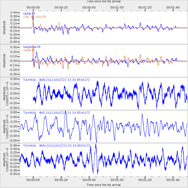
Signal To Noise
| Channel | StoN | STA | LTA |
| TA:H40A: :BHZ:20121001T22:33:39.850017Z | 2.8340275 | 3.148812E-7 | 1.11107326E-7 |
| TA:H40A: :BHN:20121001T22:33:39.850017Z | 1.066689 | 1.1993947E-7 | 1.124409E-7 |
| TA:H40A: :BHE:20121001T22:33:39.850017Z | 1.6035072 | 1.500013E-7 | 9.3545765E-8 |
| Arrivals |
| Ps | |
| PpPs | |
| PsPs/PpSs | |


