You are here: Home > Network List > G - GEOSCOPE Stations List
> Station WUS Wushi, Xinjiang Uygur, China > Earthquake Result Viewer
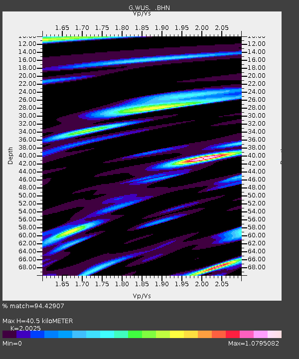
WUS Wushi, Xinjiang Uygur, China - Earthquake Result Viewer
| Earthquake location: |
Kuril Islands |
| Earthquake latitude/longitude: |
43.5/147.2 |
| Earthquake time(UTC): |
1994/11/09 (313) 18:21:03 GMT |
| Earthquake Depth: |
61 km |
| Earthquake Magnitude: |
6.1 MB, 5.8 UNKNOWN, 5.8 MW |
| Earthquake Catalog/Contributor: |
WHDF/NEIC |
|
| Network: |
G GEOSCOPE |
| Station: |
WUS Wushi, Xinjiang Uygur, China |
| Lat/Lon: |
41.20 N/79.22 E |
| Elevation: |
1457 m |
|
| Distance: |
49.0 deg |
| Az: |
292.032 deg |
| Baz: |
63.323 deg |
| Ray Param: |
0.068814404 |
| Estimated Moho Depth: |
40.5 km |
| Estimated Crust Vp/Vs: |
2.00 |
| Assumed Crust Vp: |
6.353 km/s |
| Estimated Crust Vs: |
3.173 km/s |
| Estimated Crust Poisson's Ratio: |
0.33 |
|
| Radial Match: |
94.42907 % |
| Radial Bump: |
400 |
| Transverse Match: |
87.36724 % |
| Transverse Bump: |
400 |
| SOD ConfigId: |
17000 |
| Insert Time: |
2010-02-27 00:53:48.388 +0000 |
| GWidth: |
2.5 |
| Max Bumps: |
400 |
| Tol: |
0.001 |
|

Signal To Noise
| Channel | StoN | STA | LTA |
| G:WUS: :BHN:19941109T18:29:13.350012Z | 1.1406819 | 5.112702E-8 | 4.4821455E-8 |
| G:WUS: :BHE:19941109T18:29:13.350012Z | 1.4603457 | 5.6874153E-8 | 3.8945675E-8 |
| G:WUS: :BHZ:19941109T18:29:13.350012Z | 1.3454533 | 5.77237E-8 | 4.2902794E-8 |
| Arrivals |
| Ps | 6.7 SECOND |
| PpPs | 18 SECOND |
| PsPs/PpSs | 25 SECOND |


