You are here: Home > Network List > TA - USArray Transportable Network (new EarthScope stations) Stations List
> Station F41A Wisconsin Rapids, WI, USA > Earthquake Result Viewer
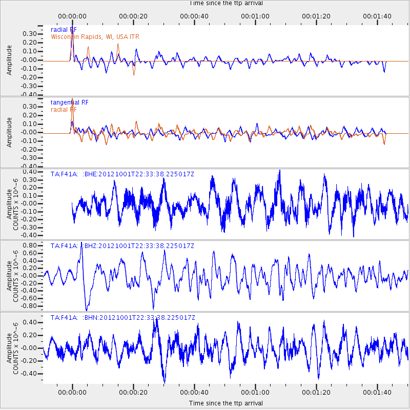
F41A Wisconsin Rapids, WI, USA - Earthquake Result Viewer
*The percent match for this event was below the threshold and hence no stack was calculated.
| Earthquake location: |
Off East Coast Of Honshu, Japan |
| Earthquake latitude/longitude: |
39.8/143.1 |
| Earthquake time(UTC): |
2012/10/01 (275) 22:21:46 GMT |
| Earthquake Depth: |
15 km |
| Earthquake Magnitude: |
5.6 MB, 5.7 MS, 6.1 MW, 6.0 MW |
| Earthquake Catalog/Contributor: |
WHDF/NEIC |
|
| Network: |
TA USArray Transportable Network (new EarthScope stations) |
| Station: |
F41A Wisconsin Rapids, WI, USA |
| Lat/Lon: |
45.74 N/89.10 W |
| Elevation: |
509 m |
|
| Distance: |
82.8 deg |
| Az: |
33.9 deg |
| Baz: |
322.159 deg |
| Ray Param: |
$rayparam |
*The percent match for this event was below the threshold and hence was not used in the summary stack. |
|
| Radial Match: |
66.04291 % |
| Radial Bump: |
363 |
| Transverse Match: |
46.663902 % |
| Transverse Bump: |
387 |
| SOD ConfigId: |
478790 |
| Insert Time: |
2013-02-23 01:37:22.582 +0000 |
| GWidth: |
2.5 |
| Max Bumps: |
400 |
| Tol: |
0.001 |
|
Signal To Noise
| Channel | StoN | STA | LTA |
| TA:F41A: :BHZ:20121001T22:33:38.225017Z | 3.711834 | 4.484966E-7 | 1.2082884E-7 |
| TA:F41A: :BHN:20121001T22:33:38.225017Z | 0.88124955 | 9.4379836E-8 | 1.0709774E-7 |
| TA:F41A: :BHE:20121001T22:33:38.225017Z | 1.3434154 | 1.446438E-7 | 1.0766871E-7 |
| Arrivals |
| Ps | |
| PpPs | |
| PsPs/PpSs | |


