You are here: Home > Network List > TA - USArray Transportable Network (new EarthScope stations) Stations List
> Station O45A Potomac, IL, USA > Earthquake Result Viewer
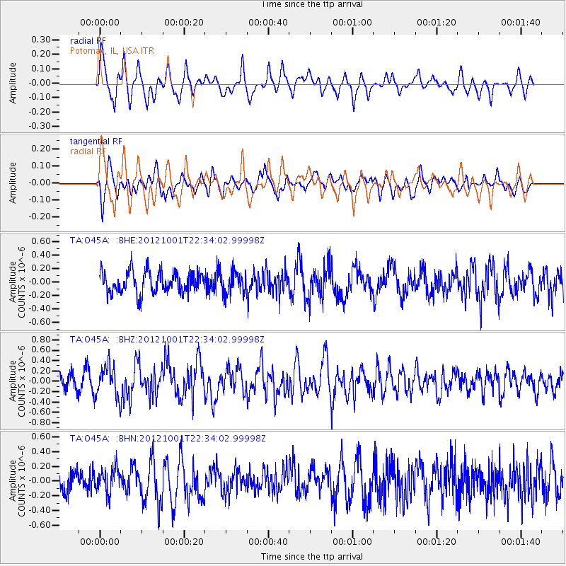
O45A Potomac, IL, USA - Earthquake Result Viewer
*The percent match for this event was below the threshold and hence no stack was calculated.
| Earthquake location: |
Off East Coast Of Honshu, Japan |
| Earthquake latitude/longitude: |
39.8/143.1 |
| Earthquake time(UTC): |
2012/10/01 (275) 22:21:46 GMT |
| Earthquake Depth: |
15 km |
| Earthquake Magnitude: |
5.6 MB, 5.7 MS, 6.1 MW, 6.0 MW |
| Earthquake Catalog/Contributor: |
WHDF/NEIC |
|
| Network: |
TA USArray Transportable Network (new EarthScope stations) |
| Station: |
O45A Potomac, IL, USA |
| Lat/Lon: |
40.25 N/87.72 W |
| Elevation: |
208 m |
|
| Distance: |
87.8 deg |
| Az: |
36.424 deg |
| Baz: |
323.304 deg |
| Ray Param: |
$rayparam |
*The percent match for this event was below the threshold and hence was not used in the summary stack. |
|
| Radial Match: |
62.837273 % |
| Radial Bump: |
400 |
| Transverse Match: |
60.866646 % |
| Transverse Bump: |
400 |
| SOD ConfigId: |
478790 |
| Insert Time: |
2013-02-23 01:38:11.544 +0000 |
| GWidth: |
2.5 |
| Max Bumps: |
400 |
| Tol: |
0.001 |
|
Signal To Noise
| Channel | StoN | STA | LTA |
| TA:O45A: :BHZ:20121001T22:34:02.99998Z | 2.002842 | 2.9444217E-7 | 1.4701219E-7 |
| TA:O45A: :BHN:20121001T22:34:02.99998Z | 1.2132638 | 1.725167E-7 | 1.4219226E-7 |
| TA:O45A: :BHE:20121001T22:34:02.99998Z | 1.0246824 | 1.6344035E-7 | 1.5950343E-7 |
| Arrivals |
| Ps | |
| PpPs | |
| PsPs/PpSs | |


