You are here: Home > Network List > G - GEOSCOPE Stations List
> Station WUS Wushi, Xinjiang Uygur, China > Earthquake Result Viewer
WUS Wushi, Xinjiang Uygur, China - Earthquake Result Viewer
| Earthquake location: |
Off East Coast Of Honshu, Japan |
| Earthquake latitude/longitude: |
40.2/143.7 |
| Earthquake time(UTC): |
1994/12/28 (362) 22:37:49 GMT |
| Earthquake Depth: |
33 km |
| Earthquake Magnitude: |
5.8 MB, 5.9 MS, 5.7 UNKNOWN |
| Earthquake Catalog/Contributor: |
WHDF/NEIC |
|
| Network: |
G GEOSCOPE |
| Station: |
WUS Wushi, Xinjiang Uygur, China |
| Lat/Lon: |
41.20 N/79.22 E |
| Elevation: |
1457 m |
|
| Distance: |
47.8 deg |
| Az: |
293.274 deg |
| Baz: |
68.712 deg |
| Ray Param: |
0.0696779 |
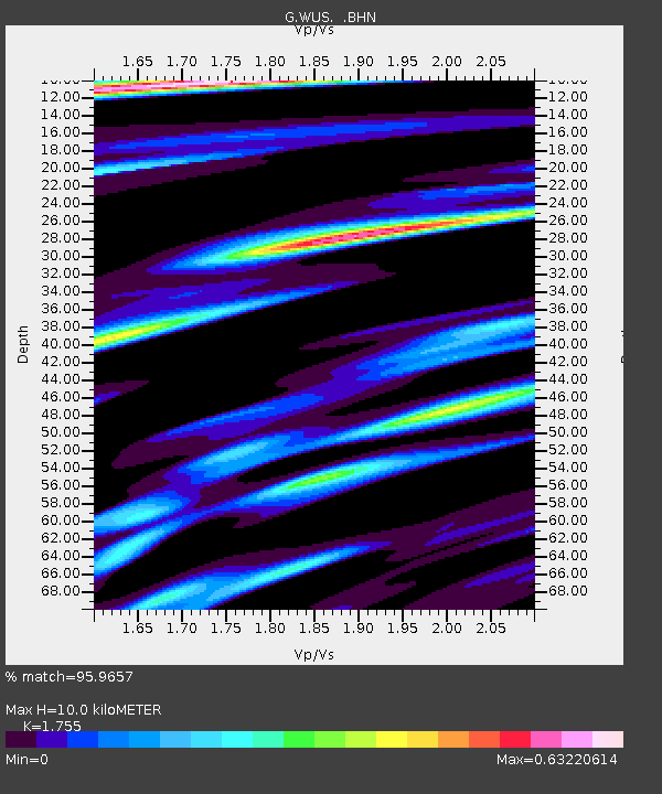
| Estimated Moho Depth: |
10.0 km |
| Estimated Crust Vp/Vs: |
1.75 |
| Assumed Crust Vp: |
6.353 km/s |
| Estimated Crust Vs: |
3.62 km/s |
| Estimated Crust Poisson's Ratio: |
0.26 |
|
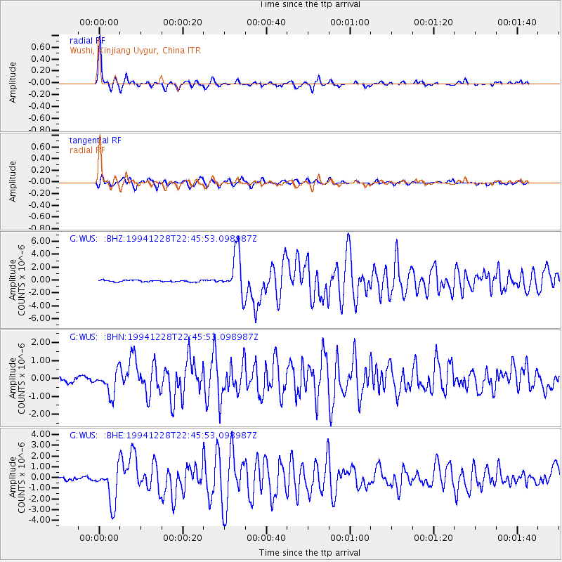
| Radial Match: |
95.9657 % |
| Radial Bump: |
318 |
| Transverse Match: |
85.354805 % |
| Transverse Bump: |
400 |
| SOD ConfigId: |
17000 |
| Insert Time: |
2010-02-27 00:53:49.742 +0000 |
| GWidth: |
2.5 |
| Max Bumps: |
400 |
| Tol: |
0.001 |
|
Signal To Noise
| Channel | StoN | STA | LTA |
| G:WUS: :BHN:19941228T22:45:53.098987Z | 4.1862307 | 6.8446553E-7 | 1.6350401E-7 |
| G:WUS: :BHE:19941228T22:45:53.098987Z | 15.197016 | 1.7554831E-6 | 1.15514986E-7 |
| G:WUS: :BHZ:19941228T22:45:53.098987Z | 26.689539 | 3.3445558E-6 | 1.2531336E-7 |
| Arrivals |
| Ps | 1.3 SECOND |
| PpPs | 4.1 SECOND |
| PsPs/PpSs | 5.3 SECOND |


