You are here: Home > Network List > G - GEOSCOPE Stations List
> Station WUS Wushi, Xinjiang Uygur, China > Earthquake Result Viewer
WUS Wushi, Xinjiang Uygur, China - Earthquake Result Viewer
| Earthquake location: |
Egypt |
| Earthquake latitude/longitude: |
28.8/34.9 |
| Earthquake time(UTC): |
1995/11/22 (326) 04:15:11 GMT |
| Earthquake Depth: |
10 km |
| Earthquake Magnitude: |
6.2 MB, 7.3 MS, 7.2 UNKNOWN, 6.2 ML |
| Earthquake Catalog/Contributor: |
WHDF/NEIC |
|
| Network: |
G GEOSCOPE |
| Station: |
WUS Wushi, Xinjiang Uygur, China |
| Lat/Lon: |
41.20 N/79.22 E |
| Elevation: |
1457 m |
|
| Distance: |
38.0 deg |
| Az: |
58.995 deg |
| Baz: |
265.357 deg |
| Ray Param: |
0.07582124 |
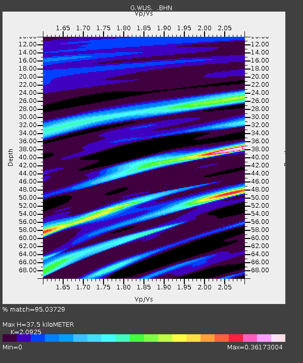
| Estimated Moho Depth: |
37.5 km |
| Estimated Crust Vp/Vs: |
2.09 |
| Assumed Crust Vp: |
6.353 km/s |
| Estimated Crust Vs: |
3.036 km/s |
| Estimated Crust Poisson's Ratio: |
0.35 |
|
| Radial Match: |
95.03729 % |
| Radial Bump: |
237 |
| Transverse Match: |
57.239502 % |
| Transverse Bump: |
400 |
| SOD ConfigId: |
6273 |
| Insert Time: |
2010-02-27 00:53:58.861 +0000 |
| GWidth: |
2.5 |
| Max Bumps: |
400 |
| Tol: |
0.001 |
|

Signal To Noise
| Channel | StoN | STA | LTA |
| G:WUS: :BHN:19951122T04:21:58.848987Z | 0.84383965 | 3.0777784E-8 | 3.6473498E-8 |
| G:WUS: :BHE:19951122T04:21:58.848987Z | 3.6101816 | 3.6854925E-7 | 1.0208607E-7 |
| G:WUS: :BHZ:19951122T04:21:58.848987Z | 5.0741463 | 6.5340606E-7 | 1.2877163E-7 |
| Arrivals |
| Ps | 6.8 SECOND |
| PpPs | 17 SECOND |
| PsPs/PpSs | 24 SECOND |


