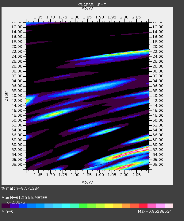
ARSB Arslanbob, Kyrgyzstan - Earthquake Result Viewer

Earthquake location: Southwest Of Sumatra, Indonesia
Earthquake latitude/longitude: -0.4/97.7
Earthquake time(UTC): 2012/10/03 (277) 13:32:34 GMT
Earthquake Depth: 9.0 km
Earthquake Magnitude: 5.6 MB, 5.5 MS, 5.7 MW, 5.5 MW
Earthquake Catalog/Contributor: WHDF/NEIC
Network: KR Kyrgyz Digital Network
Station: ARSB Arslanbob, Kyrgyzstan
Lat/Lon: 41.33 N/72.97 E
Elevation: 1378 m
Distance: 47.2 deg
Az: 334.605 deg
Baz: 145.29 deg
Ray Param: 0.070142984
Estimated Moho Depth: 61.25 km
Estimated Crust Vp/Vs: 2.09
Assumed Crust Vp: 6.306 km/s
Estimated Crust Vs: 3.021 km/s
Estimated Crust Poisson's Ratio: 0.35
Radial Match: 87.71284 %
Radial Bump: 400
Transverse Match: 83.80466 %
Transverse Bump: 400
SOD ConfigId: 478790
Insert Time: 2013-02-23 01:44:14.598 +0000
GWidth: 2.5
Max Bumps: 400
Tol: 0.001

Signal To Noise

ChannelStoNSTALTA
KR:ARSB: :BHZ:20121003T13:40:37.07501Z8.6589626.2959157E-77.270982E-8
KR:ARSB: :BHN:20121003T13:40:37.07501Z2.22391032.3811329E-71.07069646E-7
KR:ARSB: :BHE:20121003T13:40:37.07501Z1.02344181.1685025E-71.1417381E-7
Arrivals
Ps11 SECOND
PpPs29 SECOND
PsPs/PpSs40 SECOND