You are here: Home > Network List > TA - USArray Transportable Network (new EarthScope stations) Stations List
> Station O02D Mt. Diablo Meridian, CA, USA > Earthquake Result Viewer
O02D Mt. Diablo Meridian, CA, USA - Earthquake Result Viewer
| Earthquake location: |
Northern Mid-Atlantic Ridge |
| Earthquake latitude/longitude: |
17.4/-46.5 |
| Earthquake time(UTC): |
2012/10/04 (278) 23:14:56 GMT |
| Earthquake Depth: |
10 km |
| Earthquake Magnitude: |
5.5 MW, 5.0 MS, 5.4 MW, 5.3 MB |
| Earthquake Catalog/Contributor: |
WHDF/NEIC |
|
| Network: |
TA USArray Transportable Network (new EarthScope stations) |
| Station: |
O02D Mt. Diablo Meridian, CA, USA |
| Lat/Lon: |
40.18 N/122.79 W |
| Elevation: |
965 m |
|
| Distance: |
68.6 deg |
| Az: |
306.922 deg |
| Baz: |
84.893 deg |
| Ray Param: |
0.056194544 |
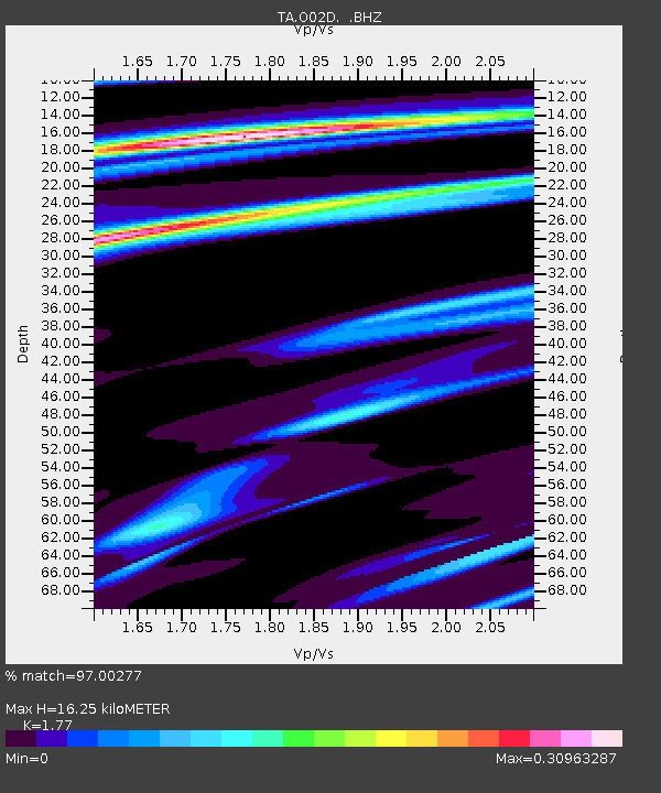
| Estimated Moho Depth: |
16.25 km |
| Estimated Crust Vp/Vs: |
1.77 |
| Assumed Crust Vp: |
6.566 km/s |
| Estimated Crust Vs: |
3.71 km/s |
| Estimated Crust Poisson's Ratio: |
0.27 |
|
| Radial Match: |
97.00277 % |
| Radial Bump: |
176 |
| Transverse Match: |
84.57123 % |
| Transverse Bump: |
115 |
| SOD ConfigId: |
478790 |
| Insert Time: |
2013-02-23 01:51:42.920 +0000 |
| GWidth: |
2.5 |
| Max Bumps: |
400 |
| Tol: |
0.001 |
|
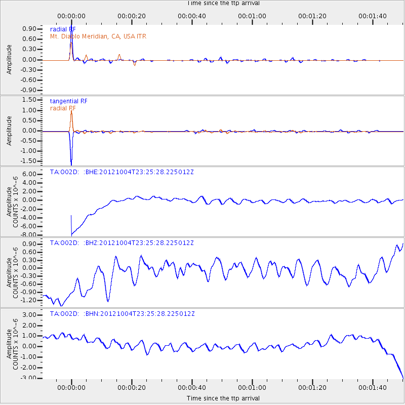
Signal To Noise
| Channel | StoN | STA | LTA |
| TA:O02D: :BHZ:20121004T23:25:28.225012Z | 0.8457299 | 3.460678E-6 | 4.0919426E-6 |
| TA:O02D: :BHN:20121004T23:25:28.225012Z | 0.9739615 | 4.234909E-6 | 4.3481273E-6 |
| TA:O02D: :BHE:20121004T23:25:28.225012Z | 0.83351284 | 2.1244978E-6 | 2.5488484E-6 |
| Arrivals |
| Ps | 2.0 SECOND |
| PpPs | 6.6 SECOND |
| PsPs/PpSs | 8.6 SECOND |


