You are here: Home > Network List > TA - USArray Transportable Network (new EarthScope stations) Stations List
> Station Y41A Eaglette Bearden, AR, USA > Earthquake Result Viewer
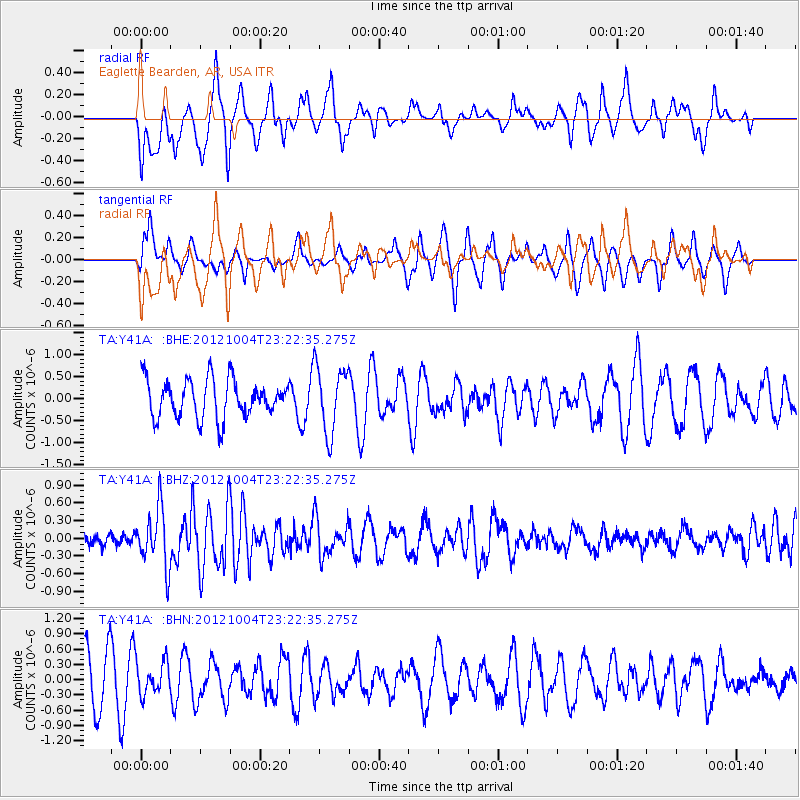
Y41A Eaglette Bearden, AR, USA - Earthquake Result Viewer
*The percent match for this event was below the threshold and hence no stack was calculated.
| Earthquake location: |
Northern Mid-Atlantic Ridge |
| Earthquake latitude/longitude: |
17.4/-46.5 |
| Earthquake time(UTC): |
2012/10/04 (278) 23:14:56 GMT |
| Earthquake Depth: |
10 km |
| Earthquake Magnitude: |
5.5 MW, 5.0 MS, 5.4 MW, 5.3 MB |
| Earthquake Catalog/Contributor: |
WHDF/NEIC |
|
| Network: |
TA USArray Transportable Network (new EarthScope stations) |
| Station: |
Y41A Eaglette Bearden, AR, USA |
| Lat/Lon: |
33.88 N/92.61 W |
| Elevation: |
99 m |
|
| Distance: |
44.3 deg |
| Az: |
300.831 deg |
| Baz: |
99.841 deg |
| Ray Param: |
$rayparam |
*The percent match for this event was below the threshold and hence was not used in the summary stack. |
|
| Radial Match: |
56.16506 % |
| Radial Bump: |
400 |
| Transverse Match: |
42.582867 % |
| Transverse Bump: |
268 |
| SOD ConfigId: |
478790 |
| Insert Time: |
2013-02-23 01:53:54.666 +0000 |
| GWidth: |
2.5 |
| Max Bumps: |
400 |
| Tol: |
0.001 |
|
Signal To Noise
| Channel | StoN | STA | LTA |
| TA:Y41A: :BHZ:20121004T23:22:35.275Z | 3.6615703 | 4.928599E-7 | 1.3460341E-7 |
| TA:Y41A: :BHN:20121004T23:22:35.275Z | 0.6473445 | 3.1513113E-7 | 4.868059E-7 |
| TA:Y41A: :BHE:20121004T23:22:35.275Z | 1.750997 | 7.549355E-7 | 4.311461E-7 |
| Arrivals |
| Ps | |
| PpPs | |
| PsPs/PpSs | |


