You are here: Home > Network List > G - GEOSCOPE Stations List
> Station WUS Wushi, Xinjiang Uygur, China > Earthquake Result Viewer
WUS Wushi, Xinjiang Uygur, China - Earthquake Result Viewer

| Earthquake location: |
Off East Coast Of Honshu, Japan |
| Earthquake latitude/longitude: |
39.7/143.7 |
| Earthquake time(UTC): |
1995/02/23 (054) 05:01:25 GMT |
| Earthquake Depth: |
33 km |
| Earthquake Magnitude: |
5.5 MB, 6.0 MS, 6.2 UNKNOWN, 6.2 MW |
| Earthquake Catalog/Contributor: |
WHDF/NEIC |
|
| Network: |
G GEOSCOPE |
| Station: |
WUS Wushi, Xinjiang Uygur, China |
| Lat/Lon: |
41.20 N/79.22 E |
| Elevation: |
1457 m |
|
| Distance: |
48.1 deg |
| Az: |
293.759 deg |
| Baz: |
69.427 deg |
| Ray Param: |
0.06952914 |
| Estimated Moho Depth: |
60.75 km |
| Estimated Crust Vp/Vs: |
1.64 |
| Assumed Crust Vp: |
6.353 km/s |
| Estimated Crust Vs: |
3.868 km/s |
| Estimated Crust Poisson's Ratio: |
0.21 |
|
| Radial Match: |
96.098946 % |
| Radial Bump: |
310 |
| Transverse Match: |
86.634895 % |
| Transverse Bump: |
400 |
| SOD ConfigId: |
6273 |
| Insert Time: |
2010-02-27 00:54:37.114 +0000 |
| GWidth: |
2.5 |
| Max Bumps: |
400 |
| Tol: |
0.001 |
|
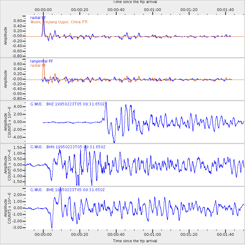
Signal To Noise
| Channel | StoN | STA | LTA |
| G:WUS: :BHN:19950223T05:09:31.650Z | 6.518159 | 4.941288E-7 | 7.580803E-8 |
| G:WUS: :BHE:19950223T05:09:31.650Z | 15.463757 | 9.773039E-7 | 6.319964E-8 |
| G:WUS: :BHZ:19950223T05:09:31.650Z | 24.328115 | 1.890753E-6 | 7.7718845E-8 |
| Arrivals |
| Ps | 6.5 SECOND |
| PpPs | 24 SECOND |
| PsPs/PpSs | 30 SECOND |


