You are here: Home > Network List > TA - USArray Transportable Network (new EarthScope stations) Stations List
> Station KSCO Kaye Shedlock's, Cheyenne Wells, CO, USA > Earthquake Result Viewer
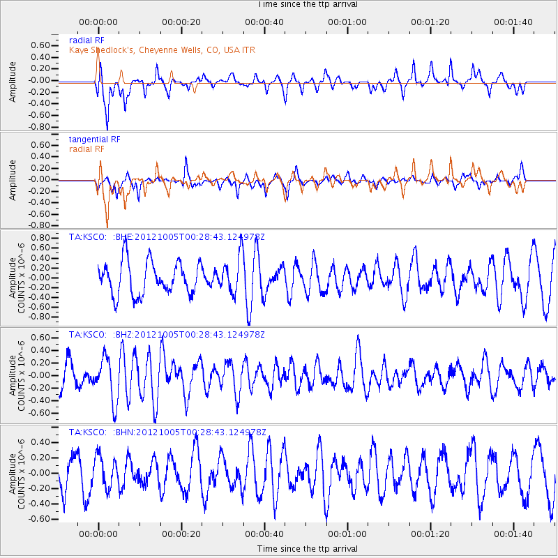
KSCO Kaye Shedlock's, Cheyenne Wells, CO, USA - Earthquake Result Viewer
*The percent match for this event was below the threshold and hence no stack was calculated.
| Earthquake location: |
Northern Mid-Atlantic Ridge |
| Earthquake latitude/longitude: |
17.5/-46.5 |
| Earthquake time(UTC): |
2012/10/05 (279) 00:19:56 GMT |
| Earthquake Depth: |
10 km |
| Earthquake Magnitude: |
5.7 MW, 5.3 MS, 5.2 MB, 5.5 MW |
| Earthquake Catalog/Contributor: |
WHDF/NEIC |
|
| Network: |
TA USArray Transportable Network (new EarthScope stations) |
| Station: |
KSCO Kaye Shedlock's, Cheyenne Wells, CO, USA |
| Lat/Lon: |
39.01 N/102.63 W |
| Elevation: |
1382 m |
|
| Distance: |
53.1 deg |
| Az: |
305.921 deg |
| Baz: |
97.227 deg |
| Ray Param: |
$rayparam |
*The percent match for this event was below the threshold and hence was not used in the summary stack. |
|
| Radial Match: |
67.403595 % |
| Radial Bump: |
388 |
| Transverse Match: |
58.70637 % |
| Transverse Bump: |
345 |
| SOD ConfigId: |
478790 |
| Insert Time: |
2013-02-23 02:07:07.952 +0000 |
| GWidth: |
2.5 |
| Max Bumps: |
400 |
| Tol: |
0.001 |
|
Signal To Noise
| Channel | StoN | STA | LTA |
| TA:KSCO: :BHZ:20121005T00:28:43.124978Z | 1.9404634 | 3.550216E-7 | 1.8295712E-7 |
| TA:KSCO: :BHN:20121005T00:28:43.124978Z | 0.9234503 | 2.0283854E-7 | 2.196529E-7 |
| TA:KSCO: :BHE:20121005T00:28:43.124978Z | 1.156497 | 3.8861393E-7 | 3.3602674E-7 |
| Arrivals |
| Ps | |
| PpPs | |
| PsPs/PpSs | |


