You are here: Home > Network List > TA - USArray Transportable Network (new EarthScope stations) Stations List
> Station Z41A Richland Creek Farm, El Dorado, AR, USA > Earthquake Result Viewer
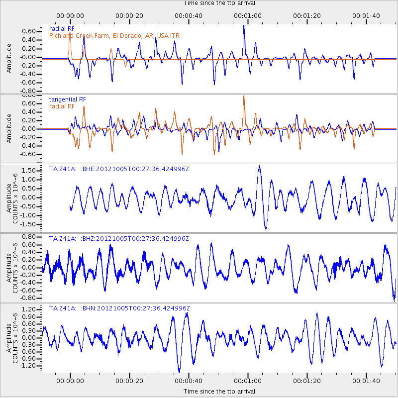
Z41A Richland Creek Farm, El Dorado, AR, USA - Earthquake Result Viewer
*The percent match for this event was below the threshold and hence no stack was calculated.
| Earthquake location: |
Northern Mid-Atlantic Ridge |
| Earthquake latitude/longitude: |
17.5/-46.5 |
| Earthquake time(UTC): |
2012/10/05 (279) 00:19:56 GMT |
| Earthquake Depth: |
10 km |
| Earthquake Magnitude: |
5.7 MW, 5.3 MS, 5.2 MB, 5.5 MW |
| Earthquake Catalog/Contributor: |
WHDF/NEIC |
|
| Network: |
TA USArray Transportable Network (new EarthScope stations) |
| Station: |
Z41A Richland Creek Farm, El Dorado, AR, USA |
| Lat/Lon: |
33.26 N/92.80 W |
| Elevation: |
62 m |
|
| Distance: |
44.4 deg |
| Az: |
299.877 deg |
| Baz: |
99.008 deg |
| Ray Param: |
$rayparam |
*The percent match for this event was below the threshold and hence was not used in the summary stack. |
|
| Radial Match: |
64.83411 % |
| Radial Bump: |
320 |
| Transverse Match: |
39.716232 % |
| Transverse Bump: |
293 |
| SOD ConfigId: |
478790 |
| Insert Time: |
2013-02-23 02:08:04.060 +0000 |
| GWidth: |
2.5 |
| Max Bumps: |
400 |
| Tol: |
0.001 |
|
Signal To Noise
| Channel | StoN | STA | LTA |
| TA:Z41A: :BHZ:20121005T00:27:36.424996Z | 0.93270093 | 2.2052309E-7 | 2.3643493E-7 |
| TA:Z41A: :BHN:20121005T00:27:36.424996Z | 0.8821947 | 2.3973266E-7 | 2.7174573E-7 |
| TA:Z41A: :BHE:20121005T00:27:36.424996Z | 1.0861411 | 4.920454E-7 | 4.5302164E-7 |
| Arrivals |
| Ps | |
| PpPs | |
| PsPs/PpSs | |


