You are here: Home > Network List > TA - USArray Transportable Network (new EarthScope stations) Stations List
> Station X46A Booneville, MS, USA > Earthquake Result Viewer
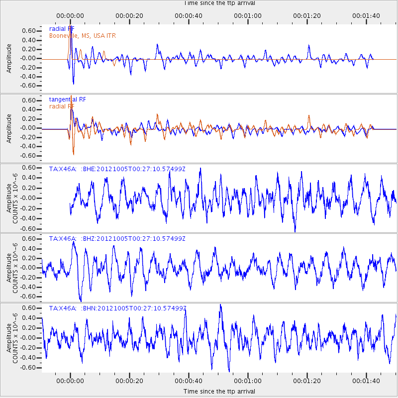
X46A Booneville, MS, USA - Earthquake Result Viewer
*The percent match for this event was below the threshold and hence no stack was calculated.
| Earthquake location: |
Northern Mid-Atlantic Ridge |
| Earthquake latitude/longitude: |
17.5/-46.5 |
| Earthquake time(UTC): |
2012/10/05 (279) 00:19:56 GMT |
| Earthquake Depth: |
10 km |
| Earthquake Magnitude: |
5.7 MW, 5.3 MS, 5.2 MB, 5.5 MW |
| Earthquake Catalog/Contributor: |
WHDF/NEIC |
|
| Network: |
TA USArray Transportable Network (new EarthScope stations) |
| Station: |
X46A Booneville, MS, USA |
| Lat/Lon: |
34.56 N/88.58 W |
| Elevation: |
150 m |
|
| Distance: |
41.2 deg |
| Az: |
302.754 deg |
| Baz: |
103.465 deg |
| Ray Param: |
$rayparam |
*The percent match for this event was below the threshold and hence was not used in the summary stack. |
|
| Radial Match: |
50.520744 % |
| Radial Bump: |
400 |
| Transverse Match: |
58.318653 % |
| Transverse Bump: |
400 |
| SOD ConfigId: |
478790 |
| Insert Time: |
2013-02-23 02:10:15.876 +0000 |
| GWidth: |
2.5 |
| Max Bumps: |
400 |
| Tol: |
0.001 |
|
Signal To Noise
| Channel | StoN | STA | LTA |
| TA:X46A: :BHZ:20121005T00:27:10.57499Z | 2.8965442 | 3.7175792E-7 | 1.2834533E-7 |
| TA:X46A: :BHN:20121005T00:27:10.57499Z | 1.0312655 | 2.0911533E-7 | 2.0277545E-7 |
| TA:X46A: :BHE:20121005T00:27:10.57499Z | 1.2732799 | 2.5456697E-7 | 1.9993008E-7 |
| Arrivals |
| Ps | |
| PpPs | |
| PsPs/PpSs | |


