You are here: Home > Network List > TA - USArray Transportable Network (new EarthScope stations) Stations List
> Station W47A Westpoint, TN, USA > Earthquake Result Viewer
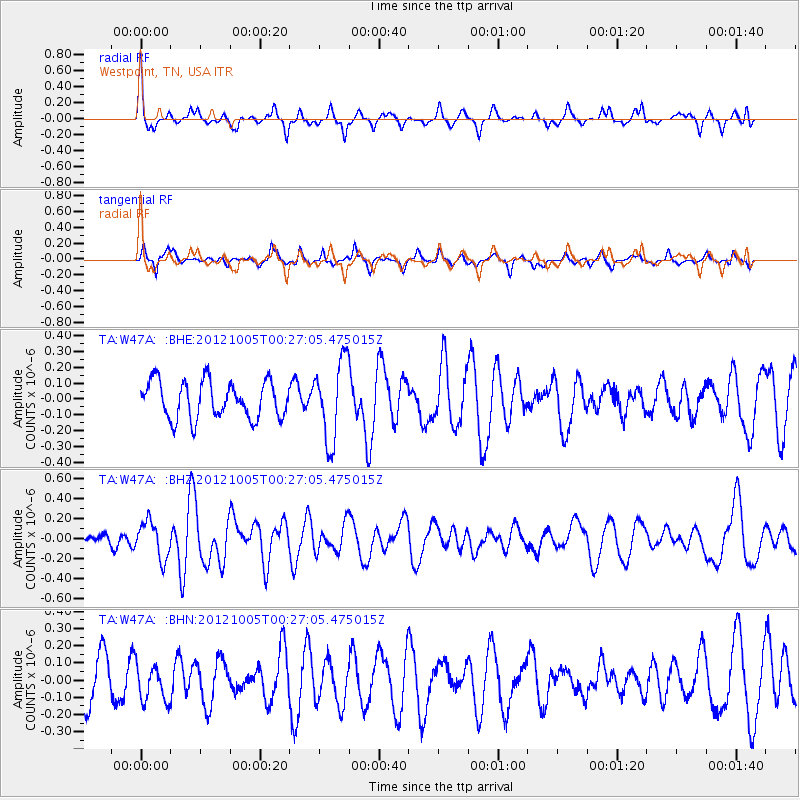
W47A Westpoint, TN, USA - Earthquake Result Viewer
*The percent match for this event was below the threshold and hence no stack was calculated.
| Earthquake location: |
Northern Mid-Atlantic Ridge |
| Earthquake latitude/longitude: |
17.5/-46.5 |
| Earthquake time(UTC): |
2012/10/05 (279) 00:19:56 GMT |
| Earthquake Depth: |
10 km |
| Earthquake Magnitude: |
5.7 MW, 5.3 MS, 5.2 MB, 5.5 MW |
| Earthquake Catalog/Contributor: |
WHDF/NEIC |
|
| Network: |
TA USArray Transportable Network (new EarthScope stations) |
| Station: |
W47A Westpoint, TN, USA |
| Lat/Lon: |
35.25 N/87.59 W |
| Elevation: |
293 m |
|
| Distance: |
40.6 deg |
| Az: |
304.087 deg |
| Baz: |
105.037 deg |
| Ray Param: |
$rayparam |
*The percent match for this event was below the threshold and hence was not used in the summary stack. |
|
| Radial Match: |
59.33198 % |
| Radial Bump: |
302 |
| Transverse Match: |
67.83015 % |
| Transverse Bump: |
372 |
| SOD ConfigId: |
478790 |
| Insert Time: |
2013-02-23 02:11:18.007 +0000 |
| GWidth: |
2.5 |
| Max Bumps: |
400 |
| Tol: |
0.001 |
|
Signal To Noise
| Channel | StoN | STA | LTA |
| TA:W47A: :BHZ:20121005T00:27:05.475015Z | 1.824843 | 1.8199881E-7 | 9.973395E-8 |
| TA:W47A: :BHN:20121005T00:27:05.475015Z | 0.7874612 | 1.05217254E-7 | 1.3361579E-7 |
| TA:W47A: :BHE:20121005T00:27:05.475015Z | 2.1559877 | 2.5220646E-7 | 1.1697954E-7 |
| Arrivals |
| Ps | |
| PpPs | |
| PsPs/PpSs | |


