You are here: Home > Network List > G - GEOSCOPE Stations List
> Station WUS Wushi, Xinjiang Uygur, China > Earthquake Result Viewer
WUS Wushi, Xinjiang Uygur, China - Earthquake Result Viewer
| Earthquake location: |
Timor Region |
| Earthquake latitude/longitude: |
-8.4/125.1 |
| Earthquake time(UTC): |
1995/05/14 (134) 11:33:21 GMT |
| Earthquake Depth: |
33 km |
| Earthquake Magnitude: |
6.1 MB, 6.9 MS, 7.1 UNKNOWN, 6.9 MW |
| Earthquake Catalog/Contributor: |
WHDF/NEIC |
|
| Network: |
G GEOSCOPE |
| Station: |
WUS Wushi, Xinjiang Uygur, China |
| Lat/Lon: |
41.20 N/79.22 E |
| Elevation: |
1457 m |
|
| Distance: |
64.9 deg |
| Az: |
323.257 deg |
| Baz: |
128.337 deg |
| Ray Param: |
0.058594175 |
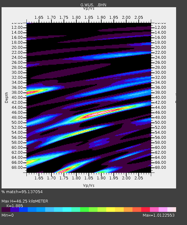
| Estimated Moho Depth: |
46.25 km |
| Estimated Crust Vp/Vs: |
1.88 |
| Assumed Crust Vp: |
6.353 km/s |
| Estimated Crust Vs: |
3.37 km/s |
| Estimated Crust Poisson's Ratio: |
0.30 |
|
| Radial Match: |
95.137054 % |
| Radial Bump: |
400 |
| Transverse Match: |
86.44415 % |
| Transverse Bump: |
400 |
| SOD ConfigId: |
6273 |
| Insert Time: |
2010-02-27 00:55:03.410 +0000 |
| GWidth: |
2.5 |
| Max Bumps: |
400 |
| Tol: |
0.001 |
|

Signal To Noise
| Channel | StoN | STA | LTA |
| G:WUS: :BHN:19950514T11:43:26.849011Z | 9.261399 | 2.7657512E-7 | 2.9863212E-8 |
| G:WUS: :BHE:19950514T11:43:26.849011Z | 8.796511 | 2.8377286E-7 | 3.2259706E-8 |
| G:WUS: :BHZ:19950514T11:43:26.849011Z | 13.68241 | 8.173547E-7 | 5.973762E-8 |
| Arrivals |
| Ps | 6.7 SECOND |
| PpPs | 20 SECOND |
| PsPs/PpSs | 27 SECOND |


