You are here: Home > Network List > G - GEOSCOPE Stations List
> Station WUS Wushi, Xinjiang Uygur, China > Earthquake Result Viewer
WUS Wushi, Xinjiang Uygur, China - Earthquake Result Viewer
| Earthquake location: |
Off East Coast Of Honshu, Japan |
| Earthquake latitude/longitude: |
39.6/143.4 |
| Earthquake time(UTC): |
1995/07/08 (189) 05:42:56 GMT |
| Earthquake Depth: |
40 km |
| Earthquake Magnitude: |
5.7 MB, 5.5 MS, 5.2 UNKNOWN, 6.0 MW |
| Earthquake Catalog/Contributor: |
WHDF/NEIC |
|
| Network: |
G GEOSCOPE |
| Station: |
WUS Wushi, Xinjiang Uygur, China |
| Lat/Lon: |
41.20 N/79.22 E |
| Elevation: |
1457 m |
|
| Distance: |
47.8 deg |
| Az: |
293.659 deg |
| Baz: |
69.596 deg |
| Ray Param: |
0.06964564 |
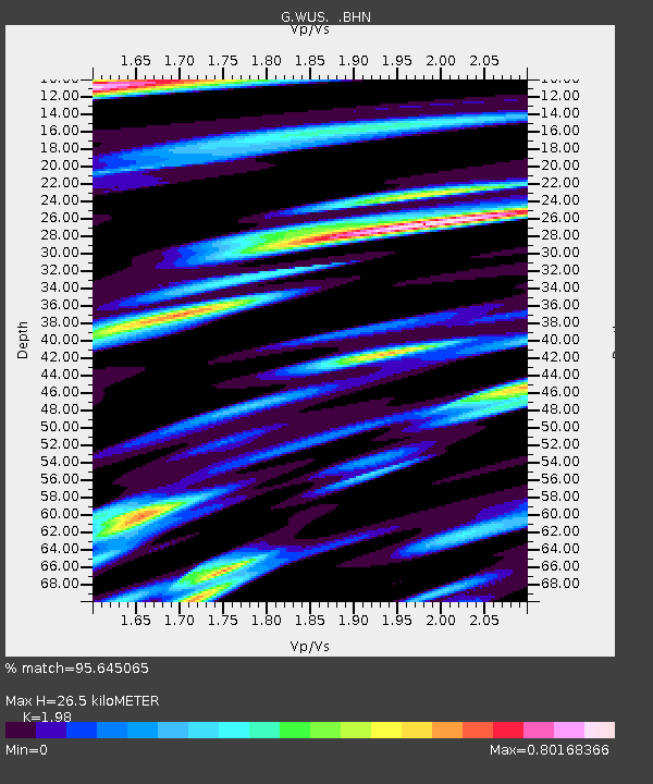
| Estimated Moho Depth: |
26.5 km |
| Estimated Crust Vp/Vs: |
1.98 |
| Assumed Crust Vp: |
6.353 km/s |
| Estimated Crust Vs: |
3.209 km/s |
| Estimated Crust Poisson's Ratio: |
0.33 |
|
| Radial Match: |
95.645065 % |
| Radial Bump: |
400 |
| Transverse Match: |
87.941414 % |
| Transverse Bump: |
400 |
| SOD ConfigId: |
6273 |
| Insert Time: |
2010-02-27 00:55:14.489 +0000 |
| GWidth: |
2.5 |
| Max Bumps: |
400 |
| Tol: |
0.001 |
|

Signal To Noise
| Channel | StoN | STA | LTA |
| G:WUS: :BHN:19950708T05:51:00.199011Z | 9.673831 | 3.140215E-7 | 3.2460925E-8 |
| G:WUS: :BHE:19950708T05:51:00.199011Z | 20.89127 | 7.846029E-7 | 3.7556493E-8 |
| G:WUS: :BHZ:19950708T05:51:00.199011Z | 33.65134 | 1.7728462E-6 | 5.268278E-8 |
| Arrivals |
| Ps | 4.3 SECOND |
| PpPs | 12 SECOND |
| PsPs/PpSs | 16 SECOND |


