You are here: Home > Network List > IW - Intermountain West Stations List
> Station PLID Pearl Lake, Idaho, USA > Earthquake Result Viewer
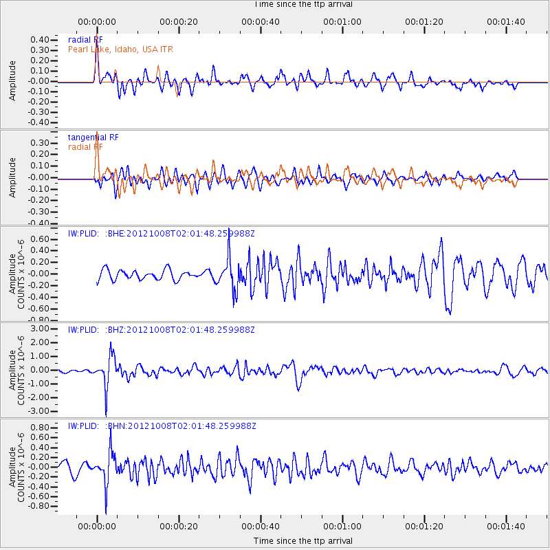
PLID Pearl Lake, Idaho, USA - Earthquake Result Viewer
*The percent match for this event was below the threshold and hence no stack was calculated.
| Earthquake location: |
Chile-Bolivia Border Region |
| Earthquake latitude/longitude: |
-21.7/-68.2 |
| Earthquake time(UTC): |
2012/10/08 (282) 01:50:26 GMT |
| Earthquake Depth: |
122 km |
| Earthquake Magnitude: |
6.0 MB, 5.7 MW, 5.8 MW |
| Earthquake Catalog/Contributor: |
WHDF/NEIC |
|
| Network: |
IW Intermountain West |
| Station: |
PLID Pearl Lake, Idaho, USA |
| Lat/Lon: |
45.09 N/116.00 W |
| Elevation: |
2164 m |
|
| Distance: |
79.5 deg |
| Az: |
327.721 deg |
| Baz: |
135.496 deg |
| Ray Param: |
$rayparam |
*The percent match for this event was below the threshold and hence was not used in the summary stack. |
|
| Radial Match: |
69.48497 % |
| Radial Bump: |
400 |
| Transverse Match: |
63.416695 % |
| Transverse Bump: |
400 |
| SOD ConfigId: |
478790 |
| Insert Time: |
2013-02-23 02:30:59.114 +0000 |
| GWidth: |
2.5 |
| Max Bumps: |
400 |
| Tol: |
0.001 |
|
Signal To Noise
| Channel | StoN | STA | LTA |
| IW:PLID: :BHZ:20121008T02:01:48.259988Z | 8.4411955 | 1.0950117E-6 | 1.2972235E-7 |
| IW:PLID: :BHN:20121008T02:01:48.259988Z | 2.6307564 | 3.2349936E-7 | 1.2296819E-7 |
| IW:PLID: :BHE:20121008T02:01:48.259988Z | 3.3597307 | 2.7627755E-7 | 8.223205E-8 |
| Arrivals |
| Ps | |
| PpPs | |
| PsPs/PpSs | |


