You are here: Home > Network List > TA - USArray Transportable Network (new EarthScope stations) Stations List
> Station 121A Cookes Peak, Deming, NM, USA > Earthquake Result Viewer
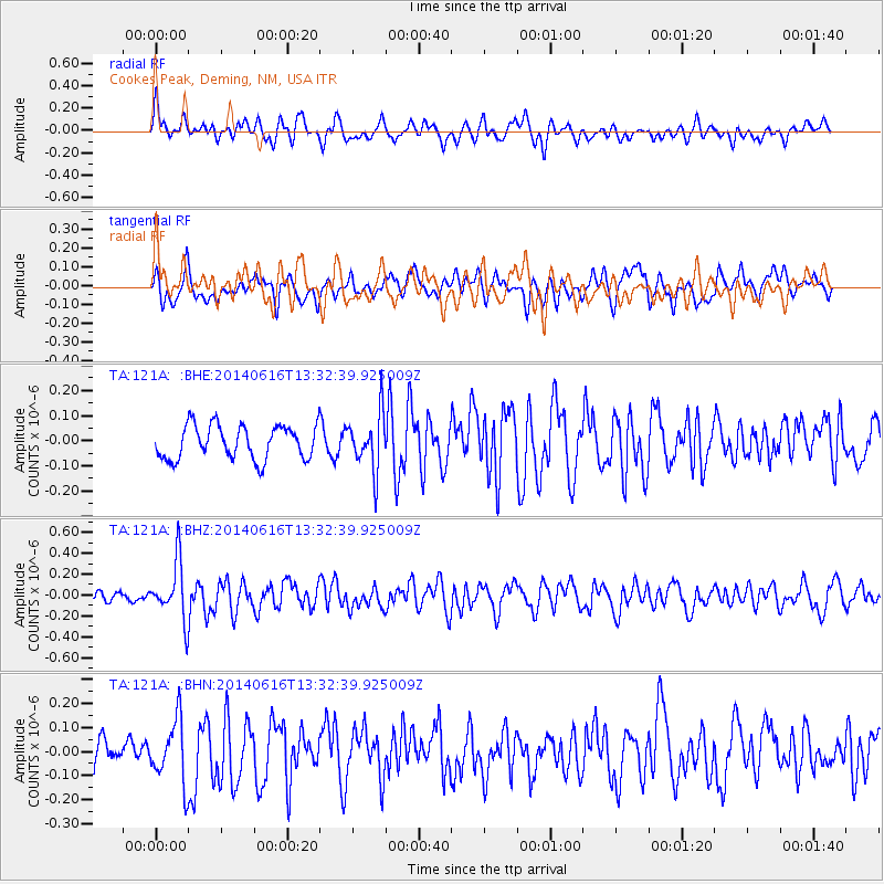
121A Cookes Peak, Deming, NM, USA - Earthquake Result Viewer
*The percent match for this event was below the threshold and hence no stack was calculated.
| Earthquake location: |
North Of Panama |
| Earthquake latitude/longitude: |
11.7/-81.3 |
| Earthquake time(UTC): |
2014/06/16 (167) 13:26:46 GMT |
| Earthquake Depth: |
19 km |
| Earthquake Magnitude: |
5.3 MW |
| Earthquake Catalog/Contributor: |
ISC/ISC |
|
| Network: |
TA USArray Transportable Network (new EarthScope stations) |
| Station: |
121A Cookes Peak, Deming, NM, USA |
| Lat/Lon: |
32.53 N/107.79 W |
| Elevation: |
1652 m |
|
| Distance: |
31.9 deg |
| Az: |
314.623 deg |
| Baz: |
124.395 deg |
| Ray Param: |
$rayparam |
*The percent match for this event was below the threshold and hence was not used in the summary stack. |
|
| Radial Match: |
51.970257 % |
| Radial Bump: |
400 |
| Transverse Match: |
51.995834 % |
| Transverse Bump: |
400 |
| SOD ConfigId: |
3390531 |
| Insert Time: |
2019-04-12 07:39:37.183 +0000 |
| GWidth: |
2.5 |
| Max Bumps: |
400 |
| Tol: |
0.001 |
|
Signal To Noise
| Channel | StoN | STA | LTA |
| TA:121A: :BHZ:20140616T13:32:39.925009Z | 3.8072875 | 2.741441E-7 | 7.200509E-8 |
| TA:121A: :BHN:20140616T13:32:39.925009Z | 1.3817105 | 1.3067664E-7 | 9.457599E-8 |
| TA:121A: :BHE:20140616T13:32:39.925009Z | 1.6625838 | 1.1177869E-7 | 6.7231916E-8 |
| Arrivals |
| Ps | |
| PpPs | |
| PsPs/PpSs | |


