You are here: Home > Network List > US - United States National Seismic Network Stations List
> Station LAO LASA Array, Montana, USA > Earthquake Result Viewer
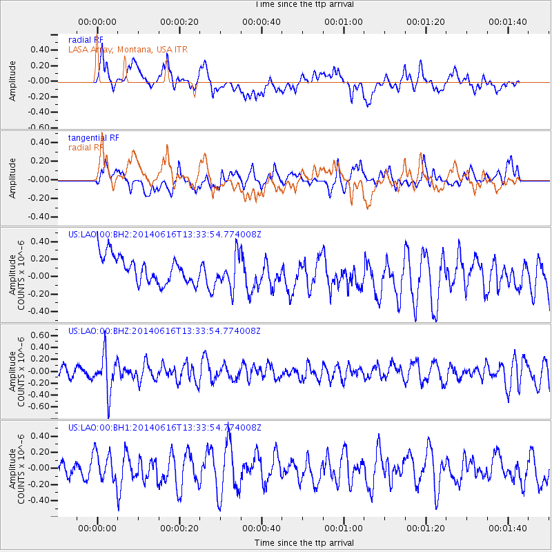
LAO LASA Array, Montana, USA - Earthquake Result Viewer
*The percent match for this event was below the threshold and hence no stack was calculated.
| Earthquake location: |
North Of Panama |
| Earthquake latitude/longitude: |
11.7/-81.3 |
| Earthquake time(UTC): |
2014/06/16 (167) 13:26:46 GMT |
| Earthquake Depth: |
19 km |
| Earthquake Magnitude: |
5.3 MW |
| Earthquake Catalog/Contributor: |
ISC/ISC |
|
| Network: |
US United States National Seismic Network |
| Station: |
LAO LASA Array, Montana, USA |
| Lat/Lon: |
46.69 N/106.22 W |
| Elevation: |
902 m |
|
| Distance: |
40.7 deg |
| Az: |
333.628 deg |
| Baz: |
140.807 deg |
| Ray Param: |
$rayparam |
*The percent match for this event was below the threshold and hence was not used in the summary stack. |
|
| Radial Match: |
50.056355 % |
| Radial Bump: |
400 |
| Transverse Match: |
42.456463 % |
| Transverse Bump: |
400 |
| SOD ConfigId: |
3390531 |
| Insert Time: |
2019-04-12 07:41:06.859 +0000 |
| GWidth: |
2.5 |
| Max Bumps: |
400 |
| Tol: |
0.001 |
|
Signal To Noise
| Channel | StoN | STA | LTA |
| US:LAO:00:BHZ:20140616T13:33:54.774008Z | 3.4748137 | 3.160128E-7 | 9.0943814E-8 |
| US:LAO:00:BH1:20140616T13:33:54.774008Z | 1.3626184 | 1.7529374E-7 | 1.2864477E-7 |
| US:LAO:00:BH2:20140616T13:33:54.774008Z | 1.2445961 | 1.8699481E-7 | 1.5024538E-7 |
| Arrivals |
| Ps | |
| PpPs | |
| PsPs/PpSs | |


