You are here: Home > Network List > TA - USArray Transportable Network (new EarthScope stations) Stations List
> Station R42A Luebbering, MO, USA > Earthquake Result Viewer
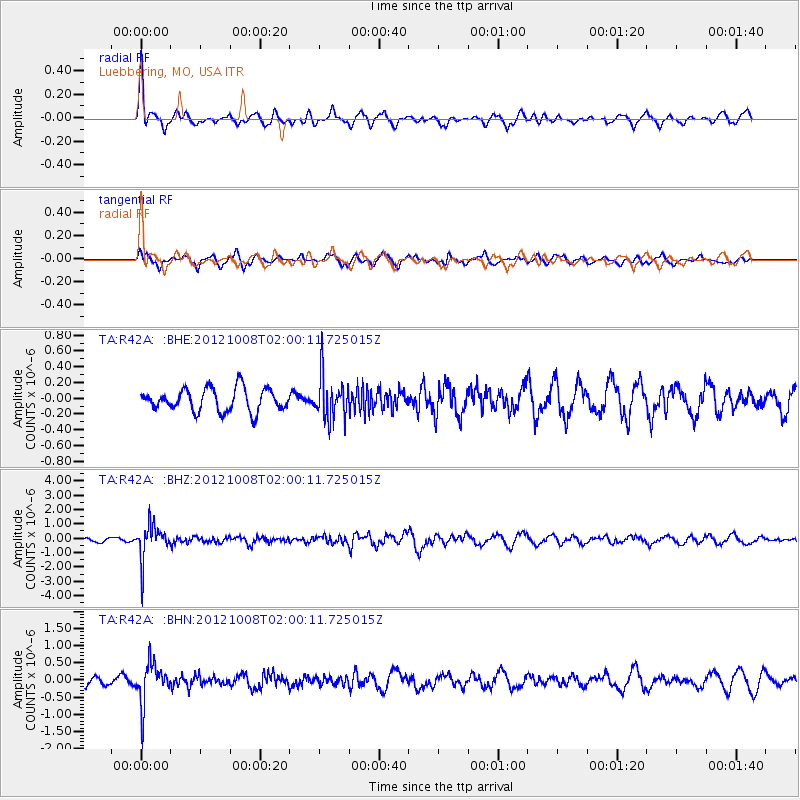
R42A Luebbering, MO, USA - Earthquake Result Viewer
*The percent match for this event was below the threshold and hence no stack was calculated.
| Earthquake location: |
Chile-Bolivia Border Region |
| Earthquake latitude/longitude: |
-21.7/-68.2 |
| Earthquake time(UTC): |
2012/10/08 (282) 01:50:26 GMT |
| Earthquake Depth: |
122 km |
| Earthquake Magnitude: |
6.0 MB, 5.7 MW, 5.8 MW |
| Earthquake Catalog/Contributor: |
WHDF/NEIC |
|
| Network: |
TA USArray Transportable Network (new EarthScope stations) |
| Station: |
R42A Luebbering, MO, USA |
| Lat/Lon: |
38.28 N/90.79 W |
| Elevation: |
218 m |
|
| Distance: |
63.4 deg |
| Az: |
340.197 deg |
| Baz: |
156.406 deg |
| Ray Param: |
$rayparam |
*The percent match for this event was below the threshold and hence was not used in the summary stack. |
|
| Radial Match: |
66.47662 % |
| Radial Bump: |
344 |
| Transverse Match: |
52.915783 % |
| Transverse Bump: |
400 |
| SOD ConfigId: |
478790 |
| Insert Time: |
2013-02-23 02:48:03.564 +0000 |
| GWidth: |
2.5 |
| Max Bumps: |
400 |
| Tol: |
0.001 |
|
Signal To Noise
| Channel | StoN | STA | LTA |
| TA:R42A: :BHZ:20121008T02:00:11.725015Z | 14.005608 | 1.2257626E-6 | 8.751942E-8 |
| TA:R42A: :BHN:20121008T02:00:11.725015Z | 4.69425 | 5.954372E-7 | 1.2684393E-7 |
| TA:R42A: :BHE:20121008T02:00:11.725015Z | 1.9352367 | 2.745871E-7 | 1.4188812E-7 |
| Arrivals |
| Ps | |
| PpPs | |
| PsPs/PpSs | |


